
MOLINE, Ill. — UPDATE: THIS SEVERE THREAT HAS PASSED THROUGH THE REGION. You can find storm and damage photos on News 8's Near Me page.
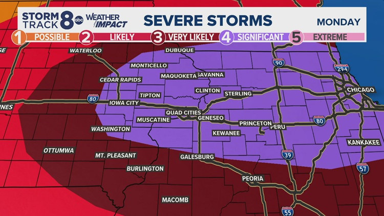
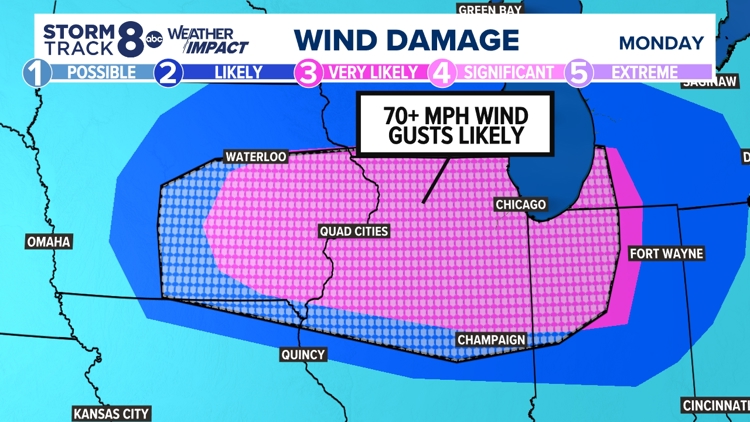
A Weather Impact Alert from the StormTrack8 team is in place Monday evening due to high heat and a significant chance of severe storms. The National Weather Service has increased the severe weather threat to a 4 out of 5 for nearly all of the viewing region, with damaging winds that could reach 70+ mph being the primary threat.
The News 8 viewing region is also under a heat advisory throughout Monday evening, as heat indices are forecasted to reach 100 to 110 degrees.
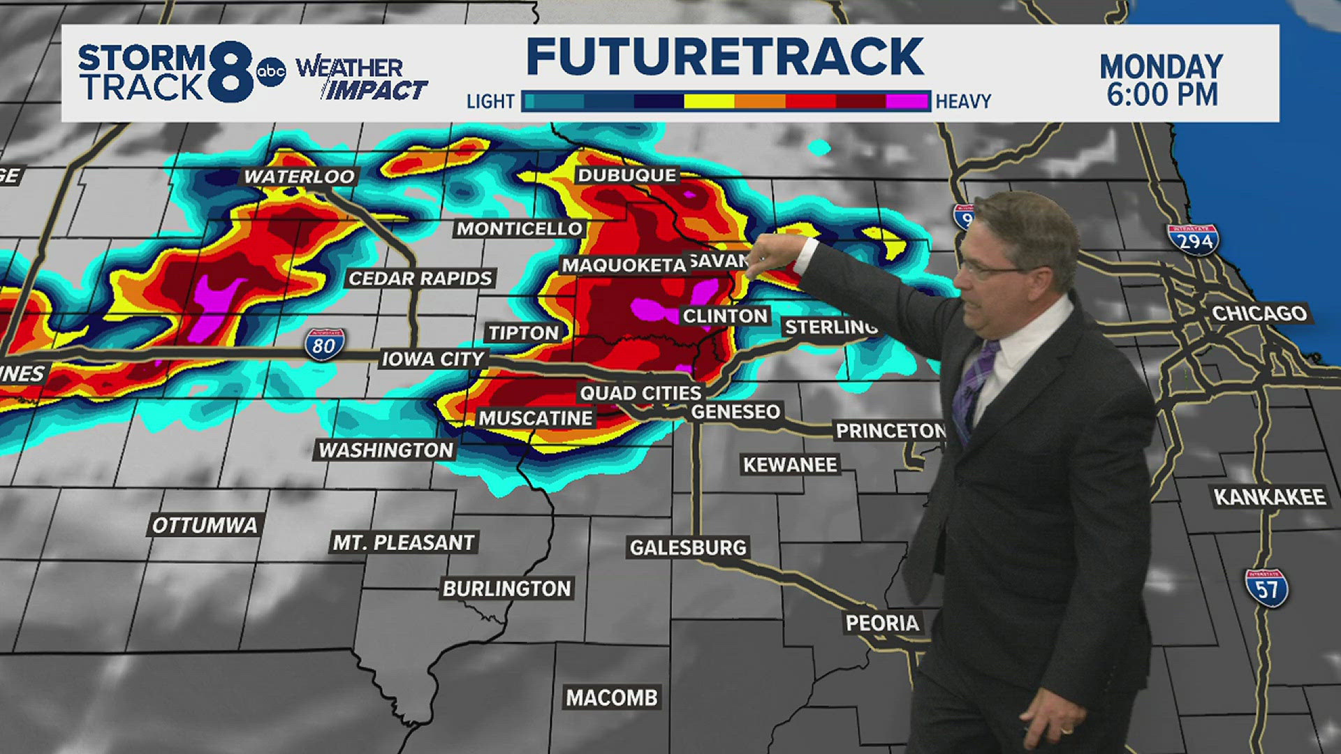
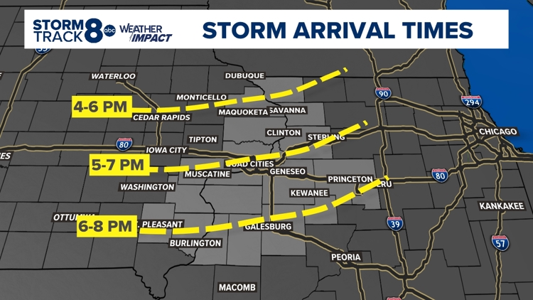
But severe storms are the main cause for Monday's StormTrack8 Weather Impact Alert. The bulk of the severe weather will come through the region from 5-9 p.m., with the main impact coming from strong winds. Watch the latest forecast from the News 8 Storm Track 8 team above.
Live Severe Weather Updates | Monday, July 15
8:31 p.m. | Severe thunderstorm warnings continue to move east with the line of storms
8:26 p.m. | Those in the Milo area asked to take cover due to strong winds with embedded rotation, NWS says
8:25 p.m. | Severe thunderstorm warning continues for Sterling, Rock Falls area
8:20 p.m. | Tornado warning for Bureau and Putnam counties in Illinois
8:10 p.m. | Severe thunderstorm warning until 9 p.m. containing
8:09 p.m. | Severe thunderstorm warning in effect for Bureau and Putnam counties
8:02 p.m. | Severe thunderstorm warning continues
7:59 p.m. | Tornado warning in effect for Peoria, Knox, Fulton, Stark and Marshall counties in Illinois
7:52 p.m. | Severe thunderstorm warning until 8:45 p.m.
7:49 p.m. | A storm near the Sterling, Rock Falls area contains wind gusts up to 80 mph
7:48 p.m. | A severe thunderstorm warning is in effect for multiple of our hometowns
7:47 p.m. | Severe thunderstorm warning for southern parts of region
7:47 p.m. | Tornado on the ground near Andover
7:45 p.m. | Tornado warning in effect for Henry, Whiteside and Bureau counties
7:40 p.m. | Severe thunderstorm warning continues
7:39 p.m. | Severe thunderstorm warning in effect for Knox, Fulton and Stark counties in Illinois
7:37 p.m. | Severe thunderstorm warning continues
7:29 p.m. | Severe thunderstorm warning continued for northern parts of the viewing region
7:29 p.m. | Severe Thunderstorm Warning including Mount Pleasant, Mediapolis and Columbus Junction.
7:27 p.m. | Low Driving Visibility
7:26 p.m. | Severe Thunderstorm Warning including East Moline, Kewanee and Monmouth
7:23 p.m. | Thunderstorms producing winds of 80 to 100 mph
7:21 p.m. | 74 mph Wind Gusts at NWS Office, Davenport.
7:15 p.m. | Tornado Warning for Moline, Rock Island and Davenport.
7:15 p.m. | Winds in excess of 70 mph headed toward the Quad Cities
7:10 p.m. | Severe Thunderstorm Warning for Galena, Mount Carroll and Stockton.
7:08 p.m. | Severe Thunderstorm Warning for Fairfield, Mount Pleasant and Wapello.
7:02 p.m. | Tornado Warning for Clinton, De Witt and Camanche.
Weather Impact Alert | Monday, July 15
Weather Impact Alert | Monday, July 15


Heat Advisory | Monday, July 15
One of the most important actions to take under a heat advisory is to stay hydrated and limit outdoor activities. However, avoid drinks with caffeine or alcohol.
Here are some other tips to keep in mind during high heat:
- Take cool showers or baths.
- Do not leave children or pets inside cars. The interior temperature can soar up to 120 degrees rapidly, according to the Red Cross.
- Wear loose-fitting, lightweight clothes. Try to avoid dark clothing that can absorb the sun's rays.
- Try to limit outdoor activities or postpone them until temperatures go down.
- Avoid intense exercising during the hottest times of the day.
- For those who have to work outdoors, take frequent breaks and put a buddy system in place in case something happens.
- Make sure to check in on those without air conditioning, who are at risk of being affected by the heat or spend a lot of time alone.
- Check on animals and make sure they have cool water and shade.
- Wear sunscreen when outside.
Signs of heat-related illnesses
It's important to know the signs of heat exhaustion in order to act accordingly. Here are some from the American Red Cross:
- Cool, moist, pale or flushed skin
- Heavy sweating
- Headache
- Nausea
- Dizziness
- Weakness
- Exhaustion
If someone is showing signs of heat exhaustion, move them to a cooler place. Remove tight clothing and spray them with water. Wet cloths or towels can also be applied to the skin. In addition, immersing the person in cool water can help.
According to the Red Cross, heat strokes usually occur when signs of exhaustion are ignored. Changes in consciousness, high body temperature and vomiting are all signs of heat stroke. If someone is showing signs of heat stroke, call 911 and work to cool them down with the tips mentioned above.
____________________________________________
Stay tuned for more from News 8 as our StormTrack8 weather team starts to roll out our new Weather Impact Alert system. It's part of our effort to provide you with the most accurate and up-to-date forecast information.
Need tips on how to stay safe during severe weather? Check out the National Weather Service's Severe Weather Safety Guidelines here.
Stay weather aware by downloading the Storm Track 8 mobile app to get live weather alerts sent straight to your phone.
Follow the StormTrack8 weather team on social media: