MOLINE, Ill. — UPDATE: This threat has passed.
An incoming wave of energy will spark more widespread scattered thunderstorms as the Quad Cities viewing area heads into the afternoon hours on Friday.
Enough storm energy will be around that an isolated severe weather threat exists for mostly hail and some gusty winds. More widespread showers and thunderstorms are likely tonight with locally heavy rainfall. Temperatures will hold in the upper 60s.
StormTrack8 is monitoring the storm as it passes through the Quad Cities area. Check below for the latest updates.
Stay weather aware:
Live Updates
9:06 p.m. | The severe threat has ended.
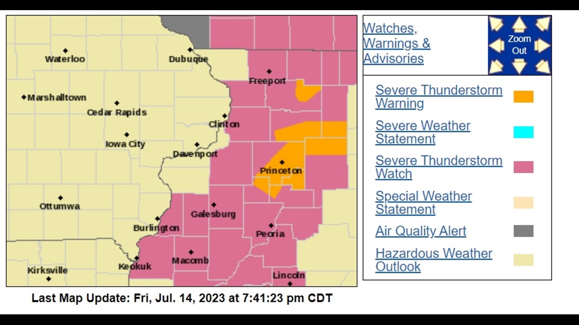
7:41 p.m. | Active watches, warnings and advisories; storm moving into Illinois

7:45 p.m. | Severe thunderstorm warning issued for Princeton, Spring Valley and De Pue until 8:30 p.m.
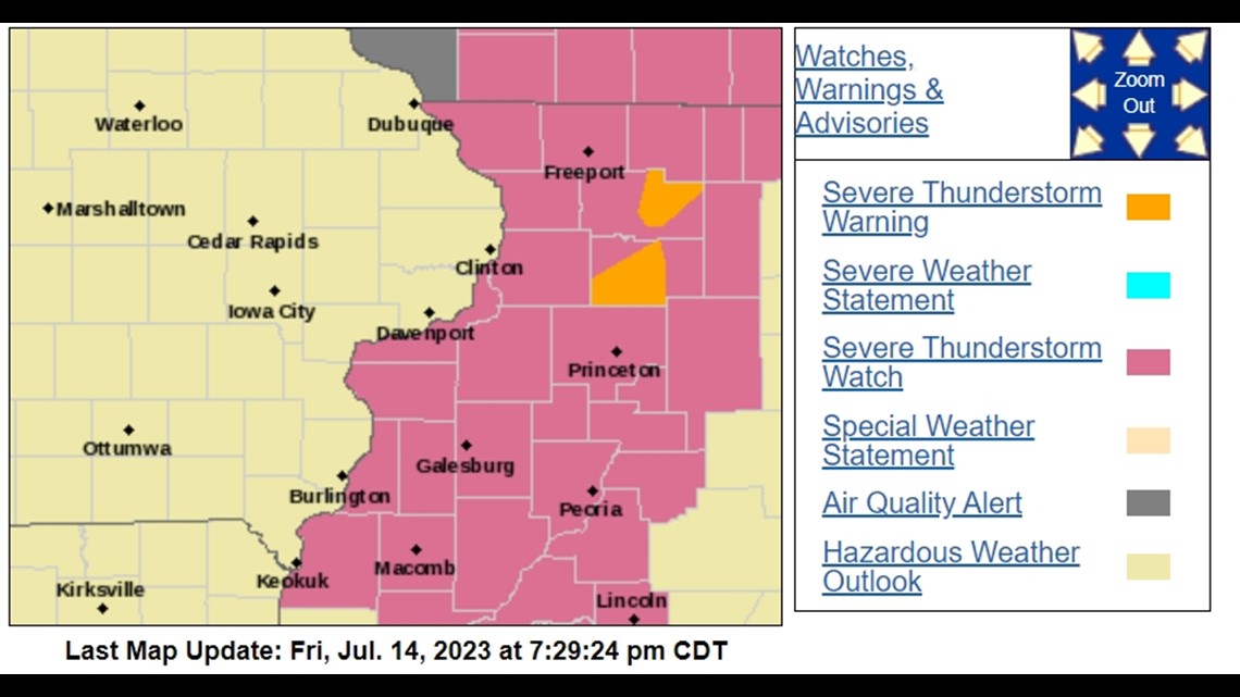
7:29 p.m. | Active watches, warnings and advisories from the National Weather Service

7:28 p.m. | Special weather statement issued for Kewanee, Princeton and Spring Valley until 8:15 p.m.
6:45 p.m. | Thunderstorms moving east into Illinois this evening
6:38 p.m. | A list of all watches and announcements for the Quad Cities region can be found here through the National Weather Service.
6:30 p.m. | WARNING: Severe thunderstorm warning issued for Woodhull, North Henderson and Burgess until 7:15 p.m.
6:23 p.m. | WARNING: Severe thunderstorm warning for towns in Illinois including Monmouth, Oquawka and Kirkwood until 7 p.m.
6:17 p.m. | Parts of the severe thunderstorm watch are canceled but still active in the greater Quad Cities area
6:06 p.m. | The special weather statement for Clinton, Sterling and Camanche has been extended to 6:45 p.m.
6:00 p.m. | The special weather statement for Davenport, Moline and Rock Island has been extended to 6:45 p.m.
5:56 p.m. | Winds between 20 and 45 mph have been detected by the National Weather Service and a few reports of hail. The main concern is heavy rain in a short amount of time, which could cause ponding of water on streets.
5:33 p.m. | A special weather statement has been issued for Clinton, DeWitt and Fulton.
5:30 p.m. | A special weather statement has been issued for Davenport, Moline and Rock Island.
5:11 p.m. | A special weather statement has been issued for Burlington, West Burlington and Beaverdale until 6 p.m. for wind and hail
5:08 p.m. | Storms continue to expand eastward and develop with heavy rain and frequent lightning. Damaging wind and large hail are possible.
4:40 p.m. | A special weather statement has been issued for Muscatine, Wilton and Columbus Junction until 6:00 p.m. Potential threats include high winds and hail
4:32 p.m. | WARNING: Severe thunderstorm warning for Maquoketa, DeWitt and Preston until 5:30 p.m.
4:16 p.m. | WARNING: Severe thunderstorm warning lasting until 5:00 p.m. in Dubuque, Jones and Jackson Counties
4:02 p.m. | Severe weather hazard probabilities for watch issued until 10 p.m.
3:51 p.m. | WATCH: A severe thunderstorm watch has been issued for News 8's entire viewing area until 10 p.m.
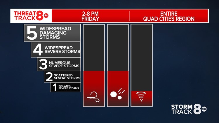
3:28 p.m. | Hail, 60-mile-per-hour winds and heavy rain are the main threats for Friday
3:15 p.m. | WARNING: The National Weather Service has issued a severe thunderstorm warning for central Iowa, including parts of Jones County. The warning ends at 4 p.m.
2:27 p.m. | A look at current conditions and temperatures, along with live Doppler radar for the hour
8:17 a.m. | Andrew predicts a few scattered severe storms tonight
A few scattered severe storms are likely with winds up to 60 miles per hour and quarter-sized hail to go along with it. Those are the main threats in this event, along with heavy rain.
Watch the latest forecast on News 8's YouTube channel