
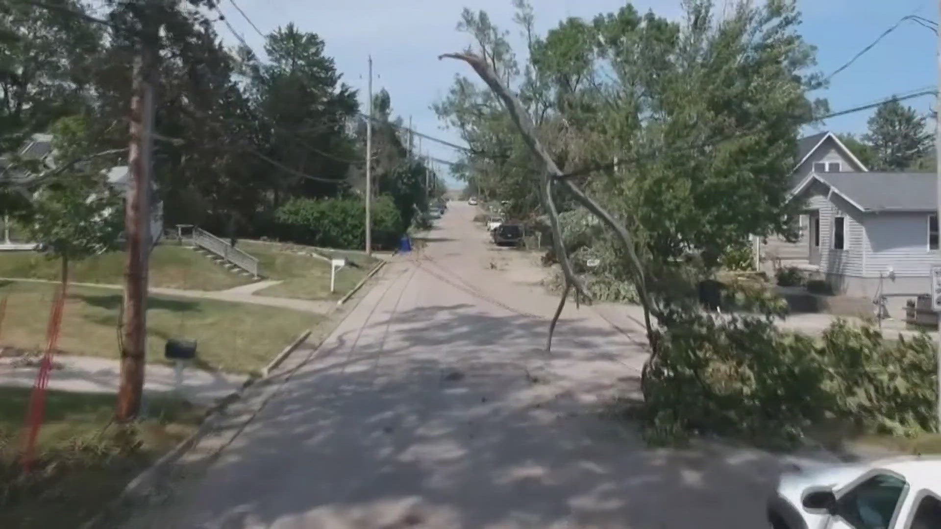
MOLINE, Ill. — Iowa and Illinois have become well acquainted with derechos over the last several years. Ever since August 10, 2020, the word derecho has seemed to pop up more and more.
However, the term "derecho" isn't new. The word came about in 1888 by Dr. Gustavus Hinrichs, a professor of physics at the University of Iowa.
These powerful and destructive storms have caused billions of dollars in damage in their wake. Dr. Walker Ashley from Northern Illinois University explains why we are hearing more about these storms.
"If you go back to the August 2020 event in Iowa and Northern Illinois, I think people that particular event really awakened not only people in the Midwest but also the insurance industry and certainly farmers. That was about a $13 billion event," Ashley said. "Compared to a tornado, they're typically not as intense, but because they're so large, and that is length and in the width, they affect a lot more people...Derechos are very difficult to forecast. I would argue that we're better at forecasting days that are going to be prolific tornado producers than derechos."
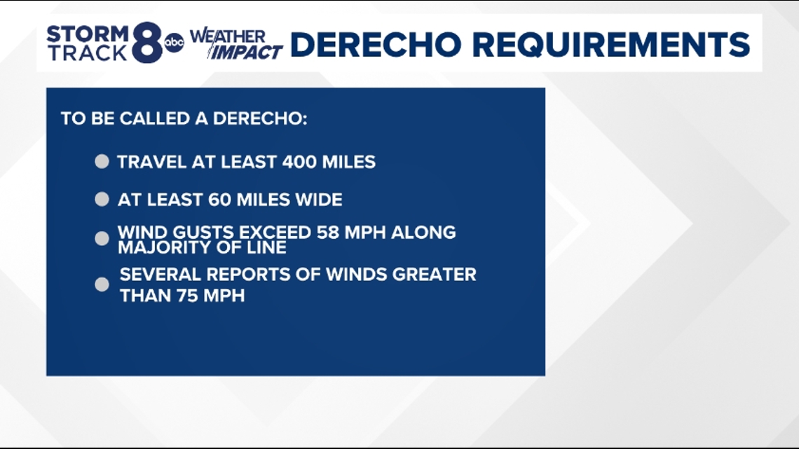
Derecho requirements
The Storm Prediction Center classifies a derecho after these storms have passed through the affected area. This is due to the fact that they must meet certain criteria before we can give these destructive storms a name.

As much as we would like to forecast these systems ahead of time, Ashley says we still have a lot to learn about these storms.
"One thing we're certain of is climate change doesn't create these events. What it could possibly do is enhance them."
"(What) we're most interested here at NIU is studying how these events are going to change in the future."
"We're finding... towards the end of the century, a near doubling or tripling of these events across the eastern part of the United States, which is, of course, very, very concerning."
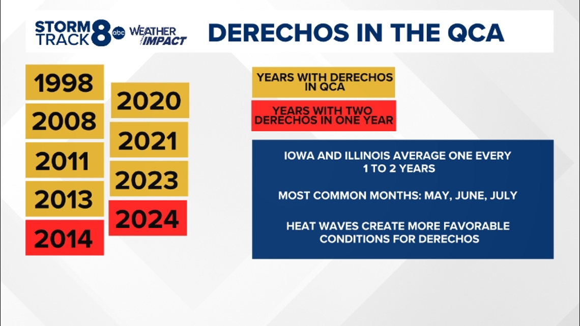
Derechos in the QCA
Due to the Quad Cities location, we are primed for derecho development. That hot and humid air, most commonly found during the summer months of May, June and July, helps sustain these storms. During this time, we have the most storm energy which helps provide the right ingredients. Think of it like baking a cake. Without the right ingredients coming together, your recipe might not work out. The same can be said for a derecho.
Ashley explains why our region tends to see more of these types of storms.
"We get a lot of flow in the upper parts of the atmosphere that comes from Canada and stretches into the southern Great Lakes. And that puts us sort of in a highway of very fast winds."
"Think of it as a sort of a large auditorium of thunderstorms. There's just a bunch of thunderstorms co-mingling. And when they do that, they tend to organize on a scale larger than their individual parts."
Over the last twenty-six years, Iowa and Illinois on average have seen a derecho every one to two years. The QCA saw the first December derecho in 2021, proving that hot summer air isn't the only singular ingredient to help produce these storms. In 2014 and 2024, we have seen at least two derechos.

One thing to remember about these storms is they are very unpredictable. Ashley reminds us that they can be deadly.
"I think that the important thing is, even though you hear, they're non tornadic or straight-line winds, they still kill. These events still fell trees, there's numerous deaths that occur in these events."
As we continue to learn from these storms, data collection and specifically storm reports help us understand their impacts.
Watch more news, weather and sports on News 8's YouTube channel