MOLINE, Ill — 2024 is off to a busy start weather-wise as another powerful winter storm is set to move through the Quad Cities region before the weekend. Multiple Winter Storm Warnings and now a rare Blizzard Warning have been issued for the Quad Cities through Saturday afternoon. Many of us are still trying to clean up from the first storm system as another one barrels down on us. This storm, however, is expected to be much more impactful thanks to colder temperatures, a lighter, fluffier nature to the snow, and more powerful winds.
How much snow did we get?
Many areas picked up close to if not just over a foot of snow with our last winter storm earlier this week. It was the most significant snowfall we've seen so far this winter season. Here's a complete listing of snowfall reports from the storm earlier this week.
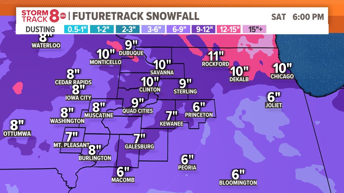
This second winter storm will also give many hometowns another generous coating of snow, with most areas picking up between 5-10 inches of snowfall. Some isolated 12" amounts are possible, especially north of I-80 by Saturday morning. This snowfall will be different than the early week snowfall, in that colder temperatures will make it slightly lighter and more fluffier. That will also allow strong winds Friday night into Saturday morning to create blizzard conditions for several hours, which is why the National Weather Service has issued a Blizzard Warning.


Are we getting hit with a blizzard?
A Blizzard Warning is the highest threat winter product that the office issues out of all other alerts. Since 1986, the Quad Cities has only been under a blizzard warning 12 times, with the most recent one issued on Dec. 22, 2022.
In order for an event to be considered a blizzard, it must feature wind gusts of at least 35 mph and visibility under 1/4 of a mile due to blowing/drifting snow for a period of at least 3 hours. Remember, it's not always about how much snow is on the ground, but rather how the wind can drive that snow through the air to greatly reduce visibility and create dangerous travel. Did you know? You can technically have a blizzard with just an inch of snow on the ground!
What's the wind chill?
This storm system will have an encore with it early next week, that being some dangerous wind chill values by Sunday and Monday morning. With a deep snowpack on the ground and an offshoot (or child) of the polar vortex moving in behind the storm itself, temperatures will plummet well below zero next week with wind chills as low as -35°F at times. A Wind Chill Watch has been issued for the entire Quad Cities beginning Saturday night and lasting through Tuesday afternoon. This will likely transition into a Wind Chill Warning by Saturday afternoon.
If you must travel
If you must travel after dark Friday night into much of Saturday, a winter weather survival kit will be absolutely necessary to have in your vehicle. Often times during blizzard warnings, tow bans are put into place and plow crews are pulled from roads. This means getting emergency vehicles and personnel to your location should you run into trouble will become very difficult.
This kit should contain:
- Extra cell phone charger or power bank
- First aid kit
- Jumper cables
- Tire chains
- Flares
- Bag of sand or cat litter for traction (you can also use your car floor mats)
- Shovel, ice scraper
- Tow rope
- Blanket
- Hats, mittens, warm clothing
- Flashlight
- Non-perishable snakes and water
You can follow the latest forecast from the Storm Track 8 Weather Team here.


