
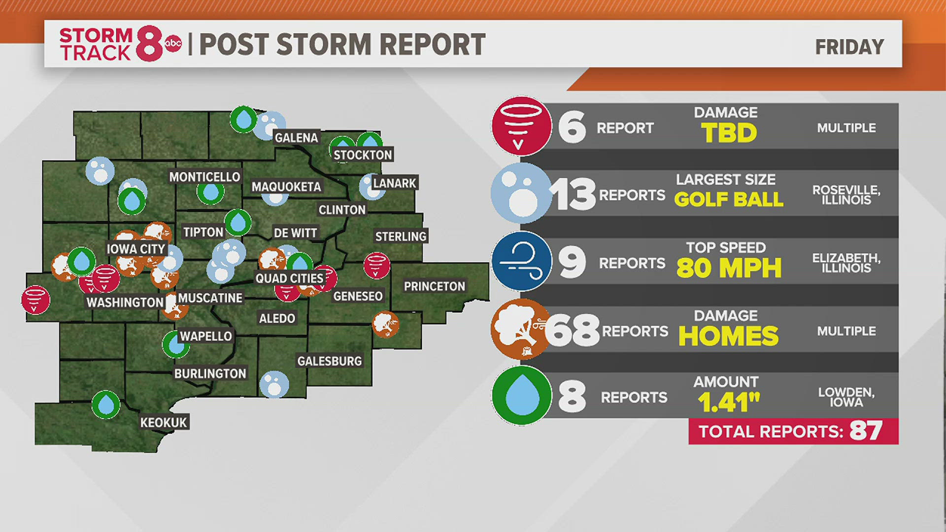
MOLINE, Ill. — Meteorologists at the National Weather Service office in the Quad Cities continue to survey the damage from Friday morning's derecho, or a line of severe storms with a long history of wind damage. In addition to strong winds, multiple tornadoes were reported as the storm system raced through the Quad Cities. A previous rare winter derecho was observed in December of 2021, preceded by the infamous record-breaking derecho of August 2020.
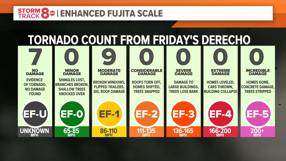
As of Monday morning, a total of 16 tornadoes have been confirmed in the Quad Cities region, including touchdowns in Rock Island and Henry counties in Illinois, and Scott County in Iowa. Thankfully, no injuries or deaths have been reported.
Where tornadoes tracked Friday morning
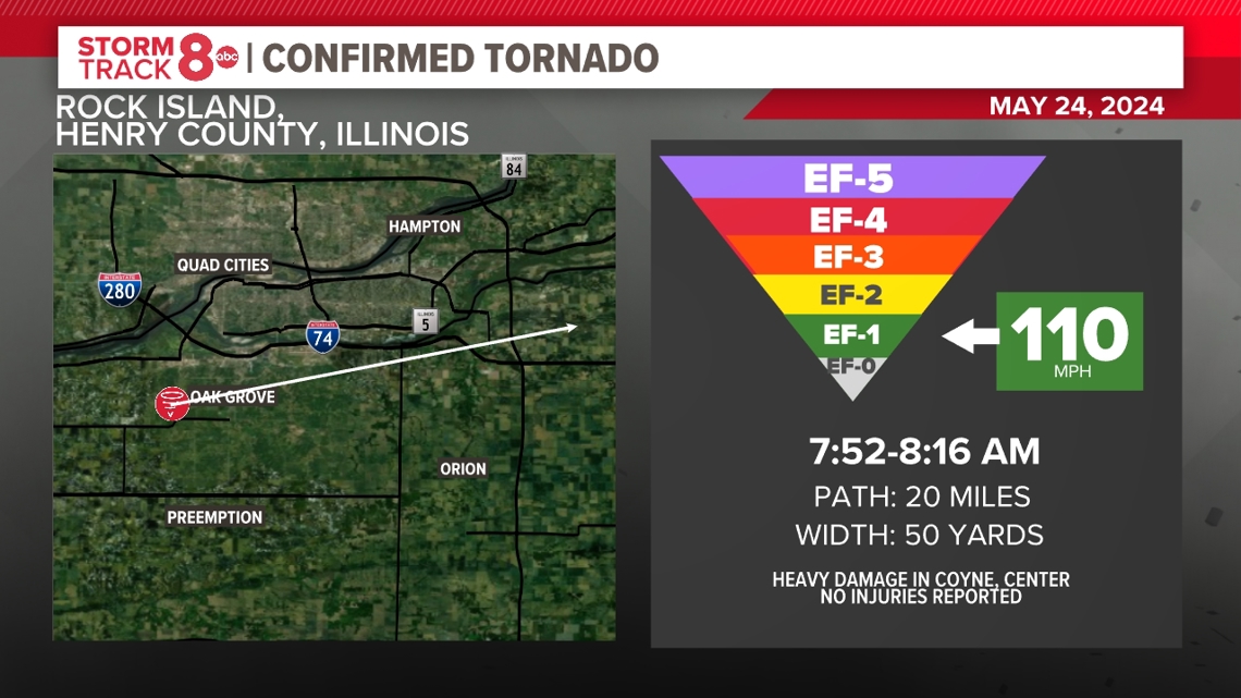
COYNE CENTER, ILLINOIS
The first tornado to touchdown in the immediate Quad Cities region impacted Coyne Center around 7:52 a.m. and traveled to the northeast for an additional 20 miles through parts of Rock Island and Henry counties. The tornado was last spotted near Green River, IL, before lifting around 8:16 a.m. Meteorologists gave this tornado an EF-1 rating and estimated the peak wind speed reached 110 mph with a maximum width of 50 yards.
The most significant damage was done to a large outbuilding and trees in Coyne Center.

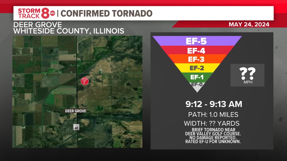
DEER GROVE, ILLINOIS
A brief tornado touched down near the Deer Valley County Club on Illinois Route 40 near Deer Grove just before 9:15 am. The tornado did not cause any damage and was rated an EF-U for unknown strength.

OHIO, ILLINOIS
Just after 9:30 am, someone captured a video of a tornado touching down southwest of Ohio, Illinois. The tornado traveled roughly half a mile before dissipating. No damage was reported and the tornado was given a rating of EF-U for unknown.
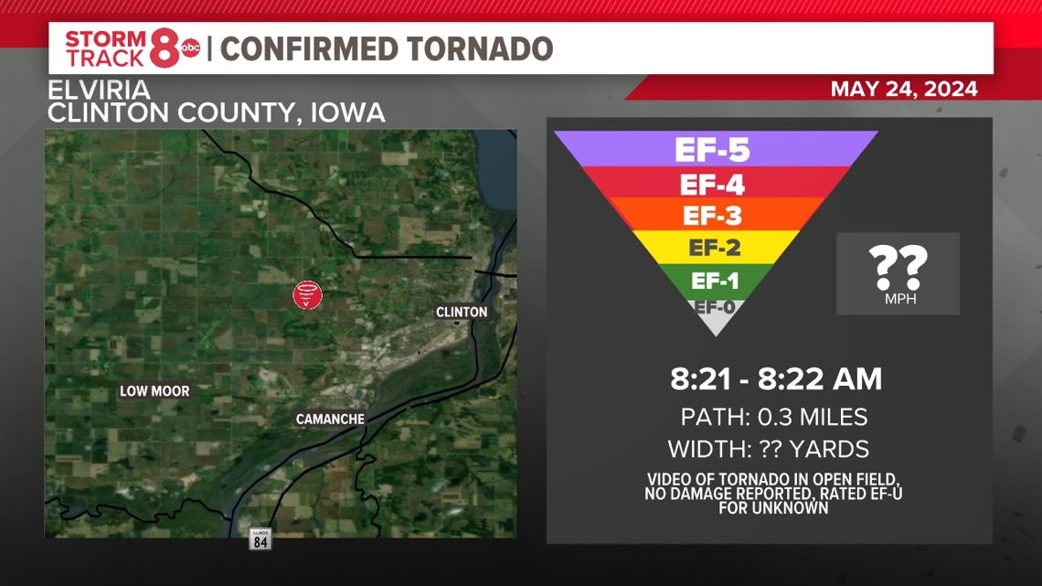
ELVIRIA, IOWA
Around 8:21 am, another person captured a video of a tornado developing near Elviria, Iowa, west of Clinton. The tornado remained in an open field and no damage was observed along its short path. The tornado was given a rating of EF-U for unknown.

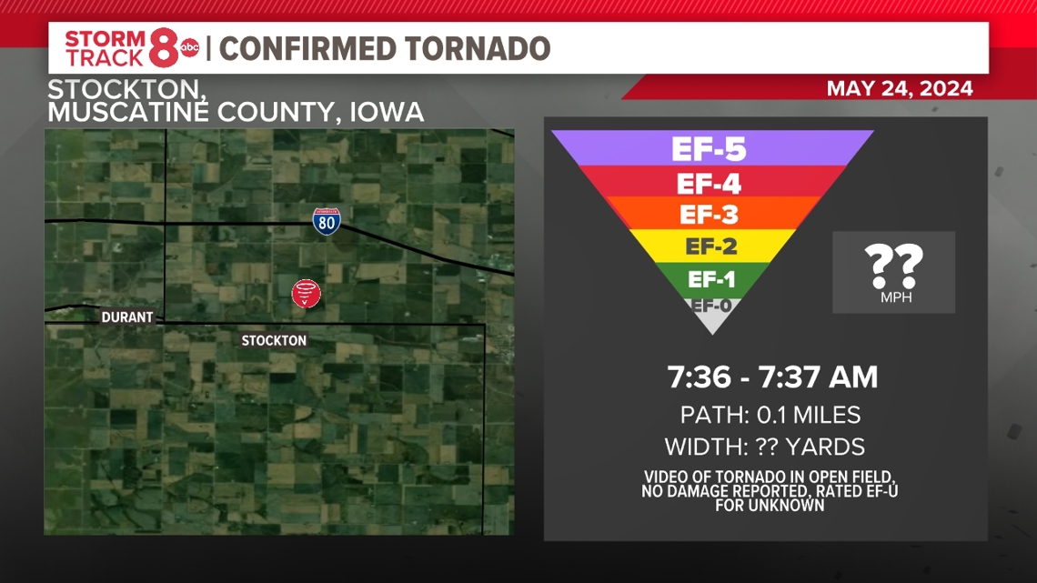
STOCKTON, IOWA
Just after 7:30 am, a tornado touched down in an open field north of Stockton, south of Interstate 80. No damage was observed along its extremely short path, less than a tenth of a mile. The tornado was rated an EF-U for unknown.

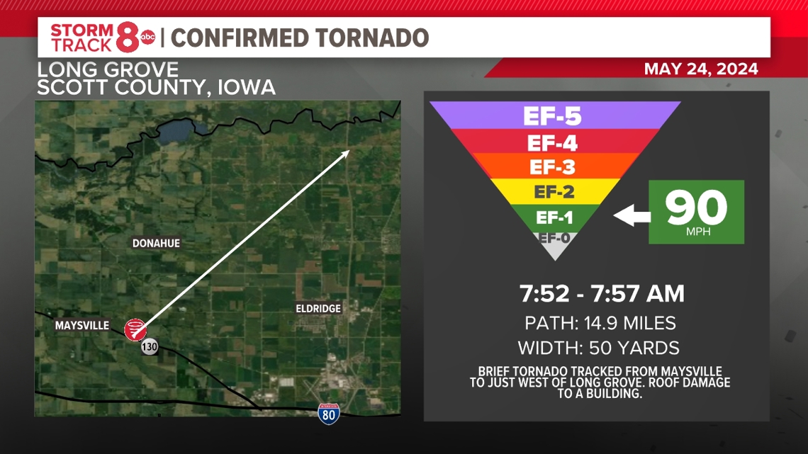
LONG GROVE, IOWA
Around 7:52 am, a tornado tracked from Maysville to just west of Long Grove, Iowa. Roof damage was found to a building. The tornado traveled a total path of nearly 15 miles and had a width of 50 yards. Meteorologists rated the tornado an EF-1 with 90 mph winds.

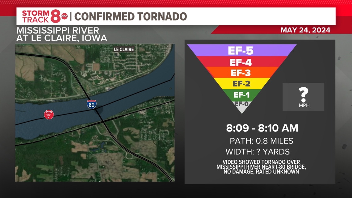
LE CLAIRE, IOWA
Video submitted to the National Weather Service showed a brief tornado over the Mississippi River between Lock and Dam 14 and the I-80 bridge around 8:09 a.m. The tornado was short-lived and did not cause any damage. The tornado is rated an EF-U, which stands for unknown strength.

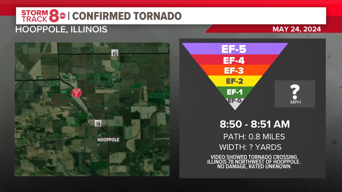
HOOPPOLE, ILLINOIS
Additional video submitted to the National Weather Service showed a tornado crossing Illinois Route 78 northwest of Hooppole, Illinois around 8:50 a.m. No damage was reported. This tornado was also rated an EF-U.

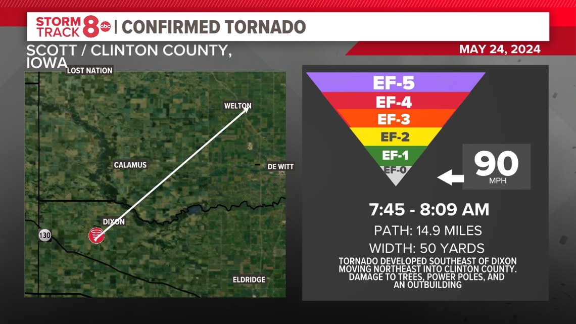
MAYSVILLE, IOWA
Another tornado touched down southeast of Dixon in Scott County around 7:45 am, traveling nearly 15 miles and lifting near Welton, Iowa around 8:09 am. The tornado originally developed with an intermittent damage path through areas east of Grand Mound before lifting near Highway 61. Minor tree and power pole damage was found along with damage to an outbuilding. No injuries were reported. The tornado was rated an EF-0 with winds of 90 mph.

ADDITIONAL TORNADOES IN IOWA
Six additional tornadoes touched down outside of the immediate Quad Cities region including one near West Branch, Iowa, which was found to have 100 mph winds and was rated an EF-1. The tornado caused tree and outbuilding damage with no injuries reported. The path of this tornado was also quite lengthy, traveling 18 miles. Another one touched down near Mechanicsville, and Solon producing damage to trees and power poles.
A sixteenth tornado was found to have touched down in Delta, Iowa, located in Keokuk County. This tornado was found to have winds up to 110 mph causing significant damage to trees and outbuildings. The tornado was short-lived with a path of only 1.6 miles.

Derecho "season" just getting started
Derechos are quite common in the Quad Cities. Many have wondered why we really haven't heard about these storm systems until recently. A lot of that can be traced back to our experience with the record-breaking derecho of August 2020. The strength of that derecho was quite rare. However, it widely introduced many of us to the type of severe wind storm that we often associate with the summer season.

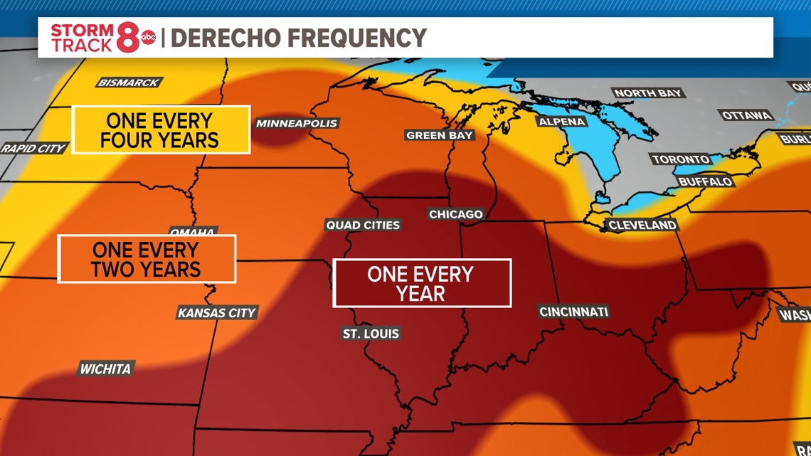
Typically the Quad Cities region experiences at least one derecho per year on average. The majority of these move through from May through August, often developing on the edge of extreme domes of heat that are located just south of the Quad Cities.
While we've logged our one derecho for the year already, that doesn't mean we couldn't see another one later down the road given our history.