MOLINE, Ill. — Severe weather in the Midwest can bring dangerous systems that develop quickly. A changing climate means better potential for tornadoes, thunderstorms, Derechos and snowstorms to be even more powerful than before.
Tornadoes
We have the lowest confidence in how tornadoes are affected by climate change in terms of frequency and intensity. This is because:
- Tornado records only date back to the 1950s.
- Tornado occurrences vary from year to year, making it difficult to determine long-term trends.
- Before 2007, our understanding of tornado wind speeds was inconsistent. In 2007, we changed to the enhanced Fujita scale, which is the new standard to measure tornado wind speeds.
Tornadoes are geographically too small to be able to do a well-simulated model that allows us to see how the frequency and intensity of tornadoes change in the future. However, models can be used to simulate the conditions that form severe thunderstorms, which tornadoes are created from.
There are four ingredients that are needed to form these storms are moisture, instability, life and shear (wind patterns). Scientists are specifically working on how instability and shear - the two main ingredients for a tornado - are responding to global warming.
Studies have shown that the conditions that produce severe thunderstorms which tornadoes can form are going to be more relatively available resulting in more severe thunderstorms which have the capability of producing more tornadoes.
Recently it seems that we are hearing more about tornadoes. That is because we are seeing an increase in eyewitness reports due to the growing population which leads to more tornadoes being recorded and more property damage occurring. Improvements in technology have also helped us be able to identify tornadoes.
We are seeing a change in tornado trends such as an increase in breakout tornado days, that is when 30 or more tornadoes occur in a day. An increase in the density of tornado clusters, tornadoes are closer together geographically, and the strength of tornadoes.
Thunderstorms
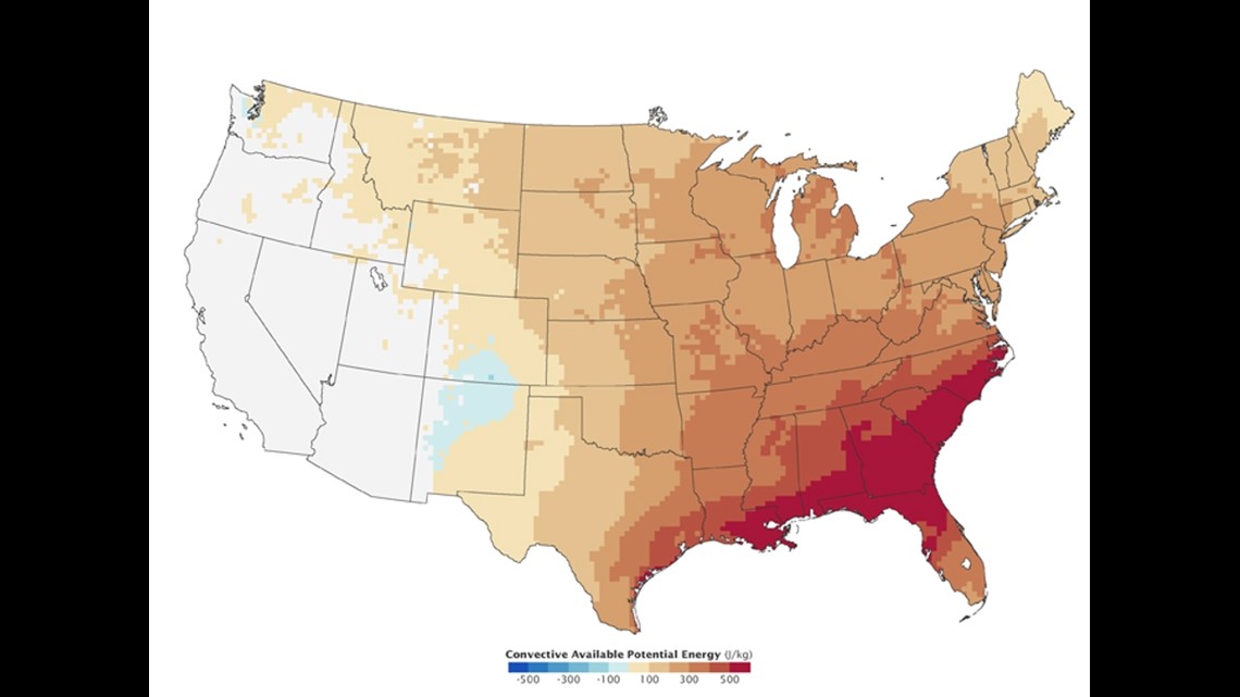
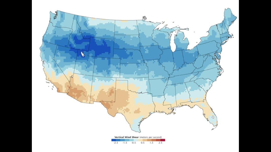
Convective Available Potential Energy is a measure of how much energy is available for storms to form. Wind shear is the measure of how the speed and direction of wind change with altitude. Each plays a vital role in thunderstorm formation.
Warming increases CAPE, putting more moisture in the air via evaporation. But the warming of the artic can lead to less wind shear in the mid-latitude that is prone to severe thunderstorms. One makes them occur more, the other less.
Unlike tornadoes, thunderstorms are large enough geographically to measure. Scientists have developed detailed climate models whose goal is to determine which of these opposing effects will dominate as the climate changes.
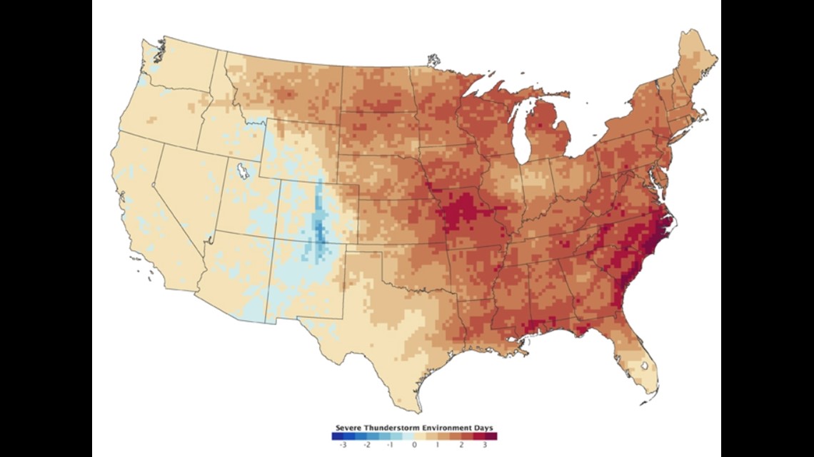
One study by Robert Trapp of Purdue University found that doubling greenhouse gases in the atmosphere could significantly increase the number of days that severe thunderstorms could occur in the southern/eastern U.S.
These three maps show the result of a model comparing the summer climate from 2072 to 2099 to the climate from 1662 to 1989. Cape (top map) is predicted to rise enough to overwhelm a slight decrease in vertical wind shear (middle), leading to an increase in thunderstorms (bottom map). Here specifically in the Quad Cities, we are expected to see a slight increase in severe thunderstorms.


However, it is very prominent that the eastern U.S. will see more of an increase in days favorable to severe thunderstorm formation than the western part of the country.
Derechos
Derechos like tornadoes can form from a thunderstorm.
As the planet warms, the jet stream would move poleward. Derechos tend to form on the equator side of the jet stream along the northern fringes of warm high-pressure systems. So, it is reasonable to conclude that the frequency of Derechos could shift poleward as the planet warms and the arctic sea ice melts.
Global Warming will cause warming in the upper air which would decrease the temperature gradient (change in temperatures), not as strong winds. To be classified as a Derechos a storm must maintain a wind gust of 58 mph for at least 240 miles.
Snowstorms
The more moisture that is evaporated from the ocean the more water we have in the atmosphere which can come down in the form of more snow during the winter. We are starting to see an increase in the frequency of snowstorms specifically in the eastern two-thirds of the U.S. in the second half of the past century.
Warmer sea surface temperatures can also contribute to the intensity of a snow storm due to more water being evaporated into the atmosphere.
Increasing sea surface temperatures and melting of arctic ice may produce atmospheric conditions that are favorable for patterns to develop in the eastern half of the U.S. More notably a greater presence of high-pressure systems over the North Atlantic results in cold outbreaks in the U.S. slowing down or becoming stationary.

