

MOLINE, Ill. — After a seemingly quiet and easy start to the winter season, 2024 is off to a blockbuster start in terms of snow and its associated impacts. Twice now in just one week, the Quad Cities has experienced two powerful winter storm systems, including a full-blown blizzard on Jan. 12.
Both systems had their unique twist impacting our region in different ways. The earlier week's system put down lots of wet, heavy snow that was tough to remove as temperatures hovered closer to the freezing mark during much of the event. This second system, however, brought a lot more impact thanks to fluffier snowfall and much stronger winds.
How much snow did this latest storm system bring?
Amounts varied of course depending on location, but overall another impressive dump from a strong winter storm. Moline observed the second-highest calendar day snowfall on record, coming in at a whopping 15.4" of fresh powder. Davenport, Clinton, Le Claire, Geneseo and several other hometowns also picked up more than a foot of new snow.

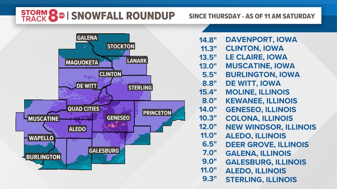
The above map shows a list of snowfall amounts from around the Quad Cities region. A complete list of all snowfall reports can be found, here.
REMINDER: There is nothing automated about measuring snowfall. Several hometowns received no reports regarding how much snow fell. Click here for a guide on how to measure snowfall and also who to send it to.
Winter snowfall now well above average in the Quad Cities
The season started very mild and of course that meant very little in the way of snow. Now, we've caught up and then some regarding the average snowfall departure from normal. As of Saturday, 28.4" of snow has fallen since Dec. 1, 2023 in Moline, Illinois. That's 15.6" more than normal for this time of year thanks to the recent storm systems. This is huge news because this snowpack has a ton of water content in it. The ongoing drought, and the fact that the ground is unlikely to freeze anytime soon since the snow acts as a blanket, means all this water will likely be absorbed into the dry ground once it melts. Both events brought more than a combined two inches of liquid water equivalent snow!
What happened to Super El Niño?
El Niño is still chugging along and the pattern we are experiencing thus far is very much on track with what we could expect. The latest Accumulated Winter Season Severity Index, which measures how extreme or mild the winter season has been so far, is still in the "mild" category, the easiest of winters.

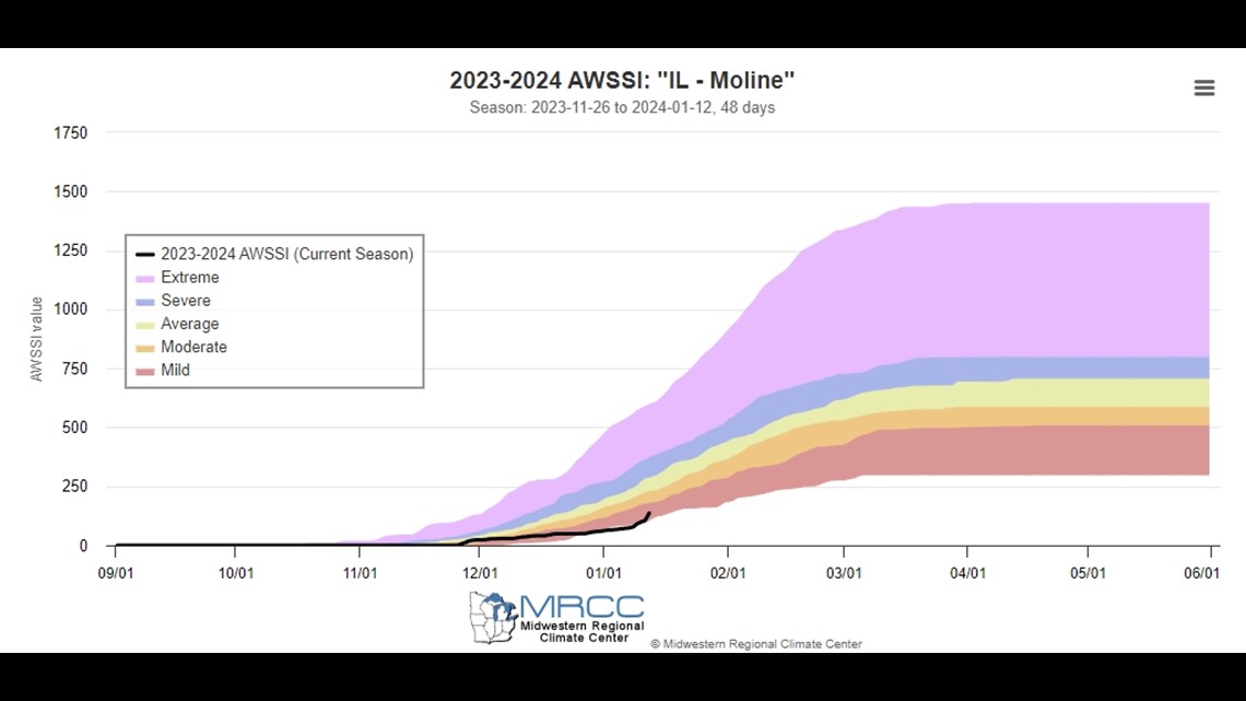
However, this is likely to change in the coming days since much colder arctic air will be arriving and our significant snowpack is expected to linger for a few weeks. The going forecast still holds in that once winter concludes, we still fully expect that the average seasonal temperature will be warmer versus normal with slightly less total seasonal snowfall.
To those folks who submitted snowfall reports, photos, and videos, we thank you!