MOLINE, Ill. — The weekend of Jan. 21-23, we had snow events every night. There was dusting on Friday. Saturday’s clipper moved further north, so our northern hometowns received anywhere from 1 to 3 inches. Sunday night, we received less than half an inch of snow.
During snow events that have occurred in the immediate Quad Cities and its surrounding towns earlier this month, the snow has been light, fluffy and powdery.
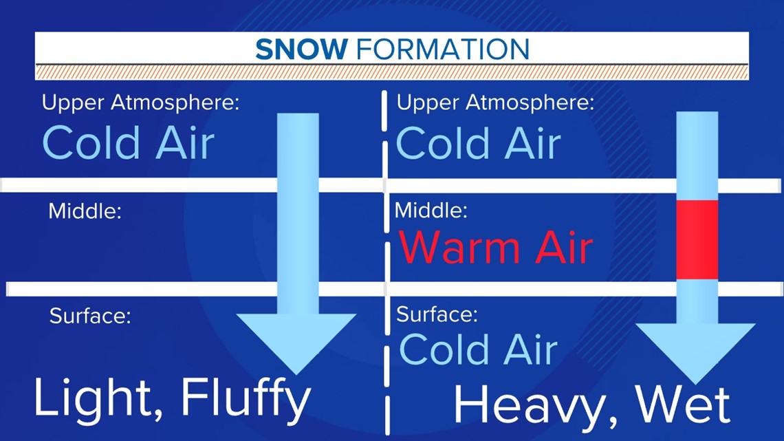
Snow can either be the light, or powdery (dry snow) like we have been experiencing or it can be heavy and wet. Dry snow forms when it is completely cold from the top of the atmosphere all the way down to the surface.
Due to this cold, dry air throughout the column, snowflakes do not stick together. This type of snow is great for snow sports or to play football in, such as this past weekend.
However, if it becomes windy after the snow has fallen, drifting becomes a major concern - especially in open areas such as the country side. Although it is easy to shovel, the lightest wind can come through and put it back in areas previously cleared. This type of snow can be dangerous because there doesn't need to be a big winter storm for it form and accumulate. Once it accumulates, it can create hazardous road conditions, and it only takes an inch of snow to create these conditions.
Wet snow occurs when at any point during the snow falling from the atmosphere to the surface the temperature gets above freezing. This causes snowflakes to melt and stick together creating heavy, wet snow. The more a snowflake melts, the heavier it becomes due to its higher water content.
Dry snow has liquid water content as well, but it's very low or frozen due the below-freezing temperatures throughout the entire atmosphere.
Heavy and wet is great for building a snow man or having a snowball fight since it's sticky. However, its harder to shovel and can cause a lot of problems such as dangerous driving conditions, power outages and structural damage.
The power outages and structural damages only occur in severe cases. Since this snow is heavier, it can cause power lines to fall or cave in, roofs to sink or tree limbs to break.


There are other factors that can affect if wet or dry snow will form besides the temperature of the atmosphere as it falls, though that does have the biggest affect. The time of day, ground temperatures and cloud cover can affect which type of snow falls.
Heavy, wet snow has a better chance occurring during the day because the sun rays can provide some melting. Light, dry snow has a better chance of occurring at night because there are no sun rays and temperatures are typically below freezing. If all the conditions are met and dry snow falls but the ground surface is above freezing, it can cause snow to melt becoming wet snow. If the wet snow falls and lands but at night when temperatures fall below freezing, the snow at the ground will have its liquid water content frozen, resulting in the hard, crusty snow that we see.
When mostly cloudy conditions occur, the sun is able to pass some of its rays through the clouds, therefore allowing for snow to melt which results in wet snow. When the sky is completely cloudy, the sun rays are not able to penetrate and the dry snow conditions are met, that is the type of snow that will fall.
At night, cloud cover does not play a role in the type of snow because there is no sun out to conceal.

