
MOLINE, Illinois — December 2023 has been remarkably warm thus far, pushing us into the top five warmest December months on record here in the Quad Cities. Mild nighttime temperatures and even warmer daytime temperatures have helped us achieve this milestone. A classic El Niño pattern has driven much of this warmth, but there is also a climate connection when you look at the long-term data. That's what we'll be diving into!
Winter is warming fast in the near-term
The most rapid warming in the U.S. has taken place when and where it's coldest, including at night, in northern parts of the country, and especially during the winter season. Winter (December, January and February) is the fastest warming season for nearly 74% of U.S. locations analyzed by Climate Central, a non-partisan, independent group of scientists.
While all seasons are generally experiencing some warmth since 1970, the amount of change in that warmth is most pronounced in the winter season.

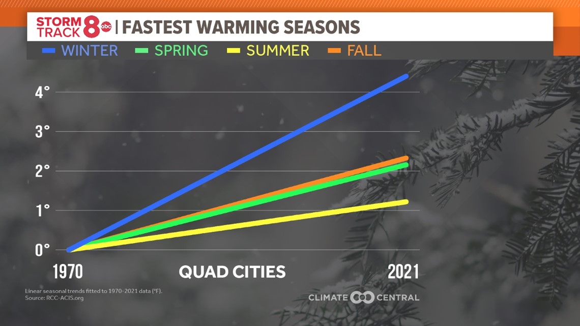
This is especially true for the Quad Cities which has seen an increase of more than 4°F in the average winter season temperature since 1970. In total, 233 U.S. cities are experiencing winter warming with an average increase in temperature of 3.8°F. Winter has warmed the most, on average, in locations across the Upper Midwest (4.7°F), Northeast (4.6°F) and Ohio Valley (4.3°F). The top five warming locations include Burlington, VT., Albany, GA., Chattanooga, TN., Milwaukee, WI. and Concord, NH.

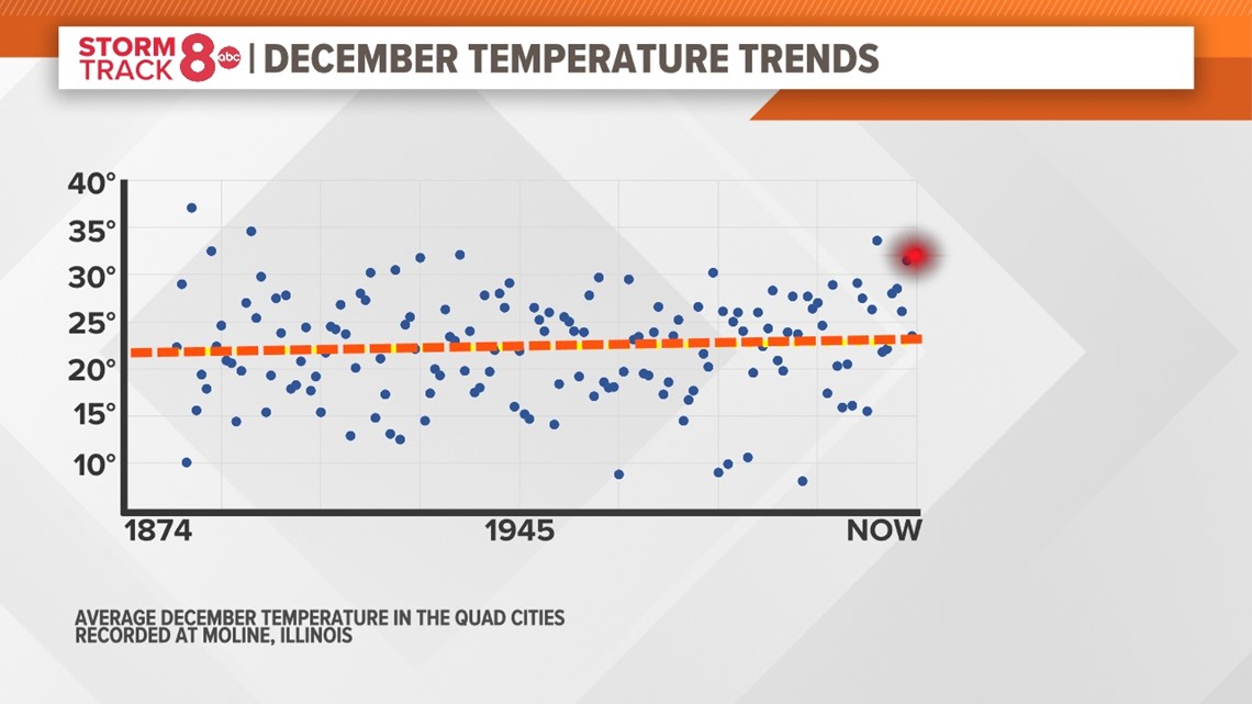
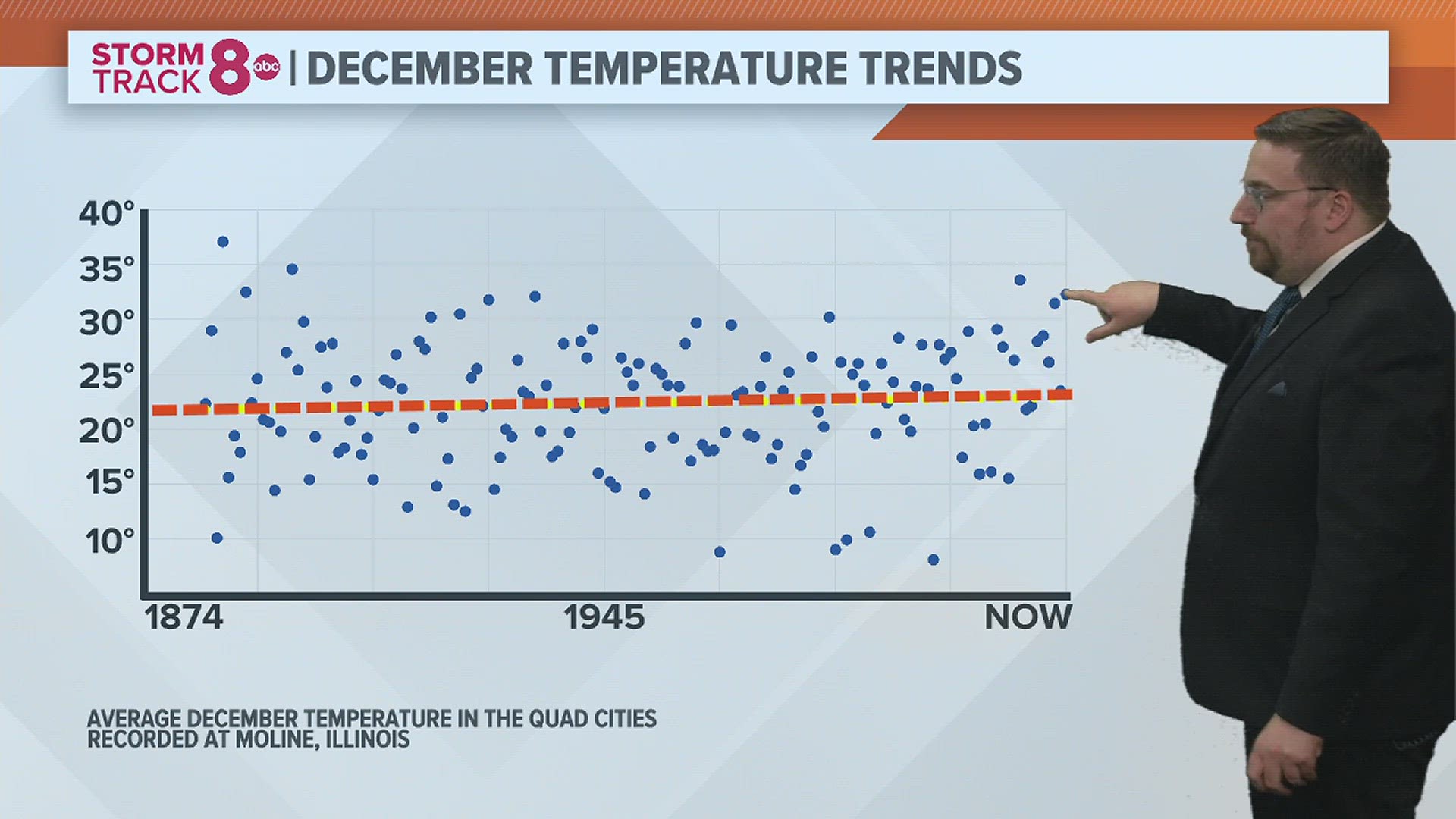
Taking this a step further, I went back and collected all of the December temperature data logged here at the Quad Cities International Airport dating back to 1874. All of this data is plotted in the graphic above, with a trendline added. That trendline shows some modest warming since the late 1800s. The red dot represents our current December average temperature as of December 20th.
Nights are still freezing, but there are fewer of them
The annual number of freezing nights has dropped at more than 200 locations in the U.S. since 1970. The average change was 13 fewer freezing nights during the winter season. While we still get blasts of cold and arctic air, they seem to be limited in number and shorter in duration. The data shows that cold snaps shrank by six days on average across more than 200 locations since the 1970s.
Consequences of a warming winter season
Cold winters can keep the populations of disease-carrying pests like mosquitoes in check. But warmer, shorter winters can worsen pest-related health risks. The change can also impact water supplies with a lack of both snow and rain. Winter sports and recreation take an especially hard hit with warmer winters, even here in the Quad Cities!
The climate change connection
While this year specifically we have El Niño to thank for the warmer-than-normal weather in December, the long-range data continues to signal a climate connection.

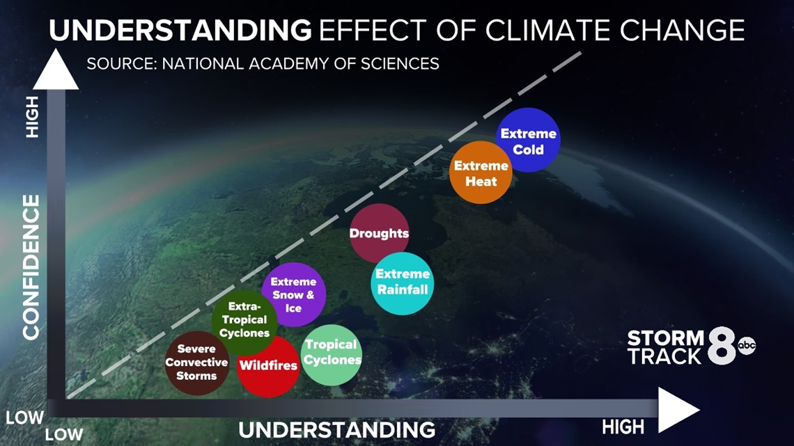
Scientists have varying levels of confidence and understanding when it comes to climate change. After all, we are talking about a giant spinning globe filled with air, water, and such. Long-term warmth or cold ranks fairly high on the understanding and confidence scale. Given what we know about our current temperature trends across the U.S., there is a lot of agreement that these warmer winters are connected when looking at the bigger picture. Yes, short-term events like El Niño can have an impact, but when you look outside of those years, there is still plenty of warmth building into the season.
Have a question that you would like me to answer for an upcoming Ask Andrew segment? Submit it, here!