
MOLINE, Ill — We still have several weeks of cold and even snow ahead of us, but already scientists at NOAA are concentrating on our next big pattern shift, a transition to La Niña by the upcoming summer. A La Niña watch has been issued even while we are still under an El Niño advisory. While rapidly weakening, this El Niño ranked in the top five in terms of strength dating back to 1950. Click here to see a refresher from Storm Track 8 University on how El Niño impacts the global weather pattern.
The state of El Niño right now
For the last few weeks water temperatures in the top 1,000 feet of the tropical Pacific Ocean have continued to show signs of significant cooling. The graph below represents the region where we track El Niño conditions. Notice how the cooler-than-normal water has grown in size and is also starting to shift east, displacing the warmer waters.

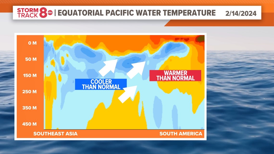
Sea surface temperatures in the key monitoring region for El Niño conditions fell from 2.0 degrees Celsius above average in December 2023 to 1.87 degrees Celsius in January 2024. Weaker trade winds were also observed across the Pacific, coming in closer to average. This signals that El Niño has likely reached its peak already. Just remember, the impacts on global rain, snow, and temperatures can linger through much of the upcoming spring season.
Where is El Niño headed
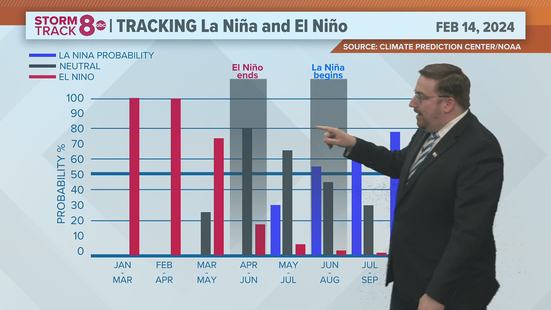
With El Niño likely to conclude by May, neutral conditions will take over through the late spring and early summer. Simply put, the global pattern won't be influenced by either El Niño or La Niña conditions as we transition between the two. However, as we stated before, lingering effects are likely.
This transition is not uncommon at all. Since 1950, more than half of the El Niño events were followed by a switch to La Niña. Most recently, this change occurred in 2010 and again in 2016.

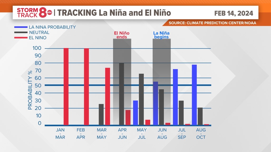
The latest long-term forecast includes a 79% probability that El Niño will collapse around May with a 55% probability of seeing the switch to La Niña conditions by July. Past historical records show a common theme of a quick transition, so, this is nothing new.
Looking ahead to spring, summer
Even while in transition, impacts on the overall weather patterns are expected for the upcoming spring and summer seasons. For example, some areas of the United States will likely see a busier severe weather season, including much of the plains and Midwest. Meteorologist Nick Stewart crunched some of the tornado data dating back to past El Niño to La Niña transition years and found that activity generally increased in the Central and Southern Plains states, including right here in the heart of the Quad Cities.

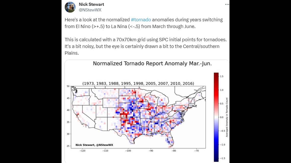
In 2016, a total of 29 tornadoes touched down in the Quad Cities region, slightly above the 10-year average of 26 tornadoes per year. That spring also featured warmer than normal temperatures with a season temperature of 2 degrees Fahrenheit warmer than normal, while rainfall was slightly less than normal.
For the United States as a whole, the probability of seeing warmer-than-normal temperatures is elevated from the Pacific Northwest, north-central plains, and through the northeast. The remainder of the country has an equal chance of either above or below-normal temperatures from March through May.
In terms of rainfall, there is a higher probability of seeing drier than normal conditions in the Pacific Northwest, and wetter than normal conditions in the central plains and southeast through that same period.
Working our way into summer, much of the nation is expected to see a higher probability of warmer than normal temperatures, especially in the west and northeast. As always, other factors will play a big role in what temperature patterns do, including areas of widespread, significant drought which still exist across much of Iowa, Minnesota and Wisconsin.
The 2024 hurricane season, from hell?
La Niña patterns are notorious for developing significant tropical systems in the Atlantic Ocean. This type of pattern typically brings less wind shear, which would normally weaken storms and tear them apart. This allows for more widespread thunderstorm activity in the Atlantic basin.
Longer-range model data points to an active season with several tropical waves originating off the coast of Africa and tracking into the Caribbean Sea.
NOAA will release its hurricane season forecast near the start of the season in June, while Colorado State University, another highly respected seasonal hurricane forecast source, is set to release its forecast for the 2024 season in April.
Have a question that you would like me to answer for an upcoming Ask Andrew segment? Submit it, here!