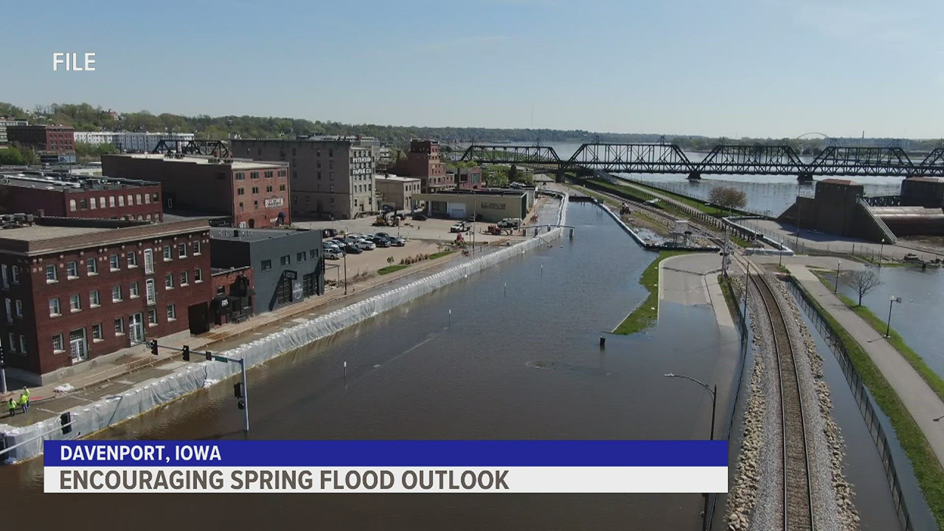
DAVENPORT, Iowa — Some areas of the Quad Cities have already experienced their first bout of river flooding of 2024 and no doubt there will likely be more episodes of flooding in the days ahead. The National Weather Service in the Quad Cities has released the first of three spring flood outlooks, giving us a glimpse into which rivers will likely give us trouble as temperatures continue to warm through May. Here's what this outlook tells us.
Flood Outlook #2: February 29, 2024
Conditions continue to support a below-average risk for flooding on the Mississippi River and its tributary rivers. Dry soil conditions, lack of new snow to the north of the Quad Cities, and a fairly quiet weather pattern recently have led to a continued low risk for flooding.
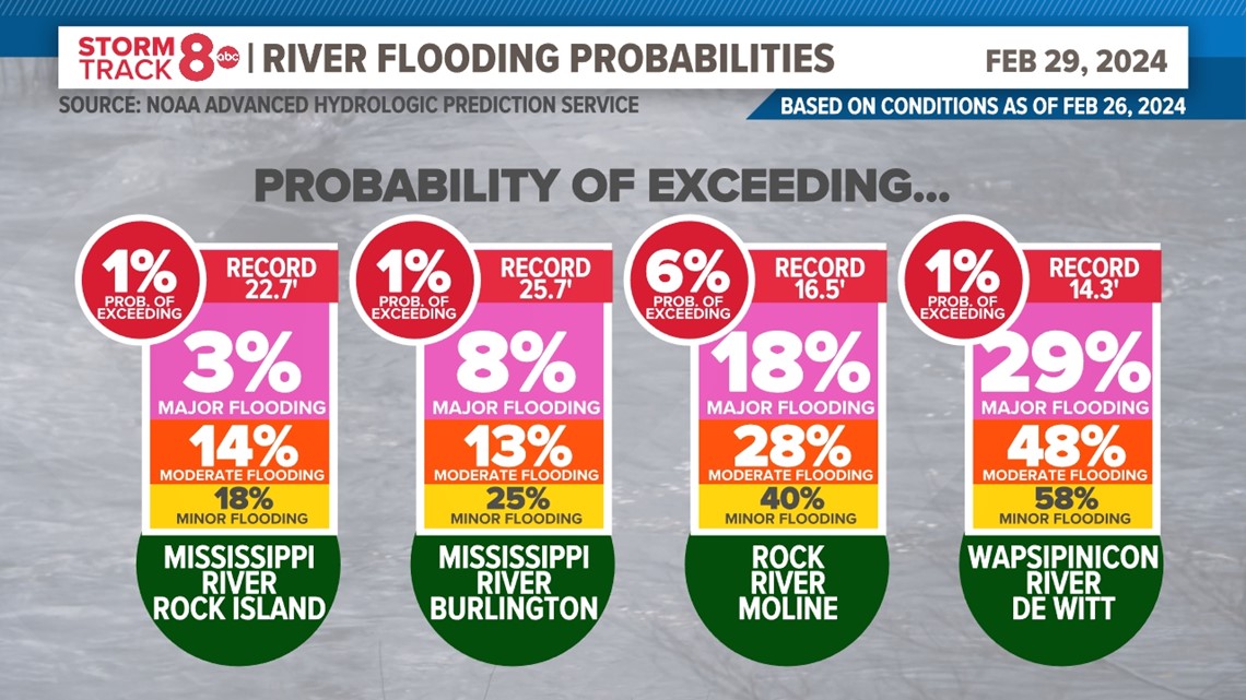
The only exception remains the Wapsipinnicon River, which is usually very sensitive to short-term weather events, like heavy rainfall. Here are the latest probabilities. A third spring flood outlook is currently not scheduled due to the low risk of flooding.

Flood Outlook #1: February 16, 2024
Winter season so far
This winter has been and continues to be heavily influenced by an El Niño pattern. This has led to above-normal temperatures so far across much of the region and above-normal snowfall here in the Quad Cities. That hasn't been the case in the north of our region, where colder temperatures and less snowfall have been observed for the season. Matt Wilson, hydrologist with the National Weather Service in the Quad Cities says this hasn't been a typical winter.
"So right now, you put about a 50-mile radius around the Twin Cities/Minneapolis and there's anywhere from a trace to, in some areas, of bare ground up there still. There's not a lot of snowpack in our headwaters area. Actually, it's kind of a reverse of what we saw last year where they had all the snow and we didn't have any. Now this year, we've got all the snow and they don't have any."

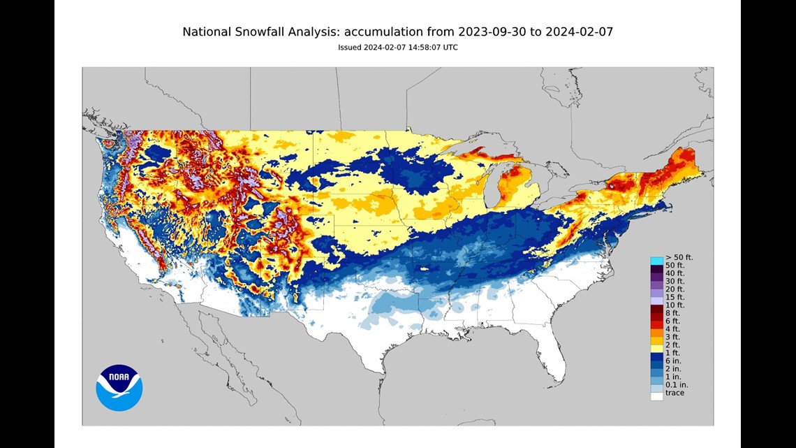
"Unfortunately, what that did was with that severe cold snap that we had, they got very cold and they didn't have that insulating snow layer. So right now, they do have some pretty deep frozen ground up north. So were they to get heavy snow you know, a couple of heavy snows in February and March, that could be cause for concern because those will be sitting on top of deep frozen ground", Wilson says.
River levels right now
For the majority of the winter season and even before, river levels have been running slightly lower than historical averages for this time of year. Thanks to recent snowmelt and even rain, river levels are slightly higher than normal, but still very much on track with levels we would expect to see for this time of year.
As of Feb. 15, the Mississippi River in Rock Island, Illinois was measured at 5.93 feet. The historical normal stage is 5.38 feet. The Rock River in Moline was measured at 9.41 feet, the flood stage being 12 feet. The Rock River remains slightly more elevated due to recent ice jam action and added water from rain/snowmelt.
Frost depth
December brought unusually warm temperatures to the Quad Cities. Before our most severe cold period of the winter so far arrived in January, a heavy round of snow fell, blanketing the ground. This kept deep frost from developing and in most areas there is only a very shallow layer of frost present. This allows water to penetrate the ground more easily, lowering the overall flood risk.
However, our neighbors to the north near the headwaters of the Mississippi River have a more substantial frost depth. Should this region receive heavy rain or snow in the next few weeks, the risk of flooding would rise since all of that water would not be able to move through the frozen ground.
Soil Moisture

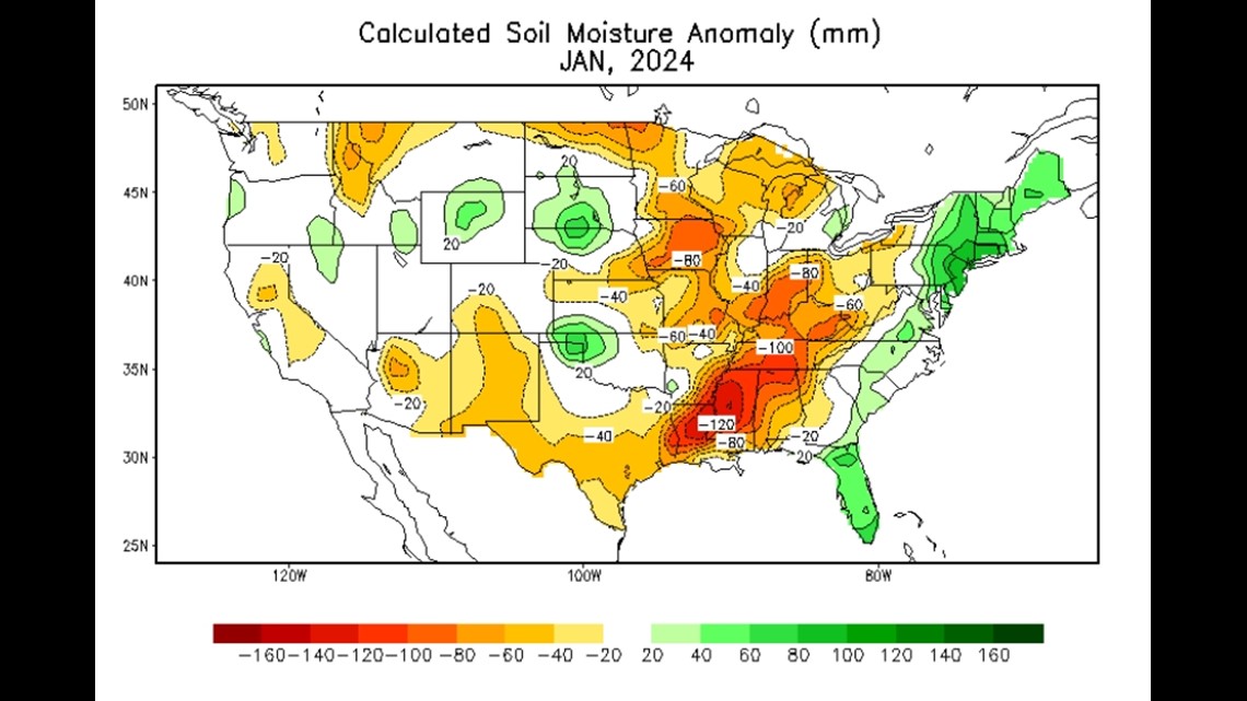
Severe drought ravages parts of Iowa, while much of Illinois remains drought-free. Wilson says that much of our soil has a pretty good capacity to handle incoming spring rains given the current conditions. "It's still drier than average soils over here on the Iowa side. So we should have good capacity in the soils to take up some of those bigger spring rain systems."
The flood outlook
All of the above factors are considered by hydrologists at the National Weather Service when predicting our springtime flood risk. Their latest prediction calls for a near-normal to slightly below-normal risk for flooding from now through the end of April.
In summary, the lack of heavy snowfall to the north, no significant frozen ground here in the Quad Cities region, and normal rivel river levels combined with dry soils, lower our overall flood risk this year. For our risk of spring flooding to increase, we would need to see one or a combination of the following happen in the next six to eight weeks:
a) A significant snow/rain event to the north of the Quad Cities where the ground is significantly frozen.
b) A period of cold air lasting several days, allowing rivers to freeze, and causing a renewed threat of ice jams, especially on the Rock River.
Flood stage probabilities
The National Weather Service breaks down the probability of each river reaching a certain flood stage in this outlook. The Mississippi River in Rock Island, Illinois, has a roughly 30% probability of reaching minor flood stage through the end of April, and only a 12% probability of reaching major flood stage. An even lower probability scenario, reaching 2019 record flood levels, is currently 2%.

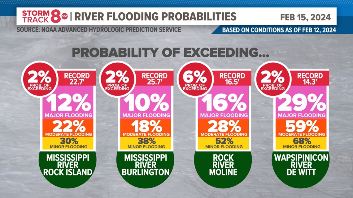
Meanwhile, the Rock and Wapsipinicon Rivers have a slightly more elevated probability of reaching both minor and moderate flood-stage, due to their size and slightly more elevated water levels with the recent snowmelt/rain.
Flood Risk Assessment for this outlook
- Mississippi River - Below normal risk
- Rock River - Normal to below-normal risk
- Wapsipinicon River - Normal to below-normal risk
- Other local rivers - Normal to below-normal risk
The next flood outlook will be released on Feb. 29 with the third and final outlook due out on March 14.

