Our quiet pattern is about to see a major disruption starting later today as a strong area of low pressure move into the Midwest. After some patchy areas of fog this morning, clouds will be back on the increase throughout the day with rain becoming likely by this evening.
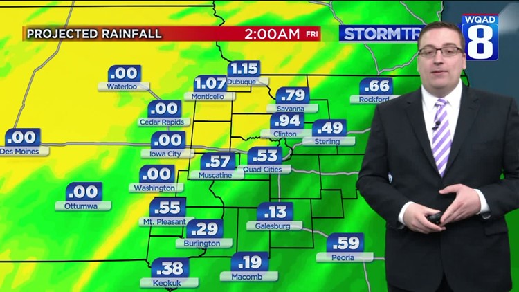
Meanwhile, further to the north and west, areas of rain mixed with snow will change to all snow creating difficult travel in parts of Iowa, Nebraska, and the Dakotas where several inches of snow looks likely through Thursday. We’ll remain on the warm side of this system keeping much of our precipitation rain through Thursday afternoon. We could even see a few thunderstorms as highs rise well into the 50s by Thursday evening. Rainfall totals of one-half inch to three-quarters of an inch will be possible along with windy conditions.
Rain will quickly come to an end Thursday night, but the winds will remain strong. Temperatures will begin falling through the day on Friday with just a slight chance of a morning snow shower, otherwise, a colder weekend expected as conditions dry out and highs struggle to get out of the 30s. Even colder temperatures are expected next week to start 2019.
Meteorologist Andrew Stutzke
Download the News 8 Weather App — for iOS, click here and for Android, click here
Download the free News 8 App — for iOS, click here and for Android, click here