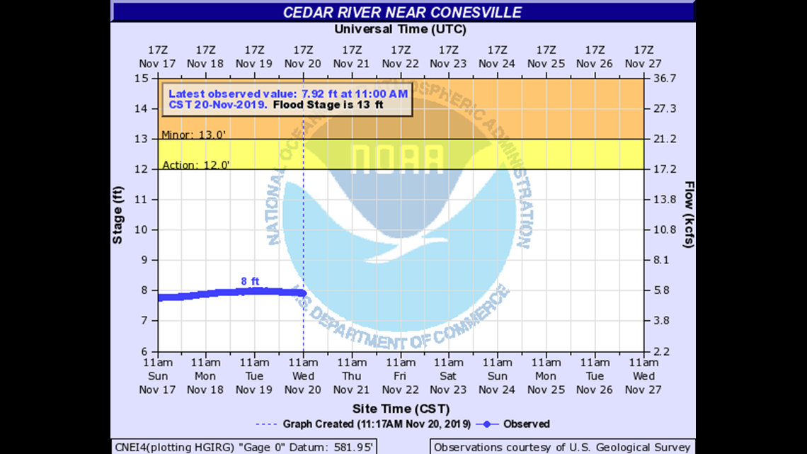
Everything you need to know about Cedar River levels
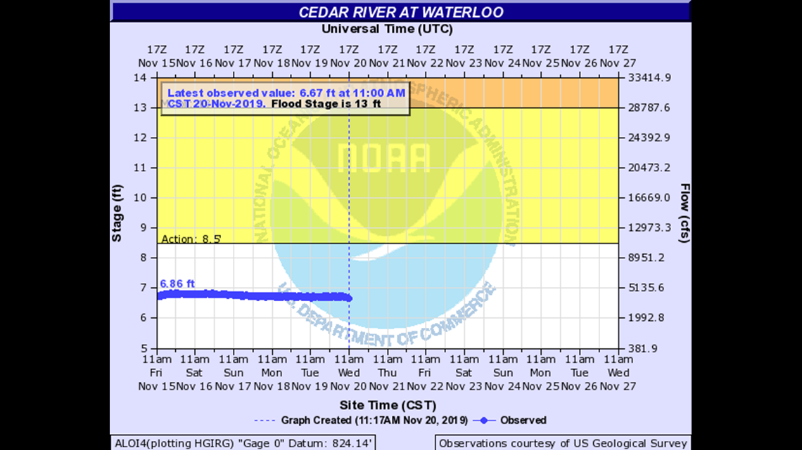
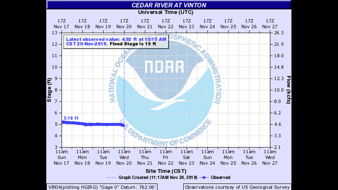
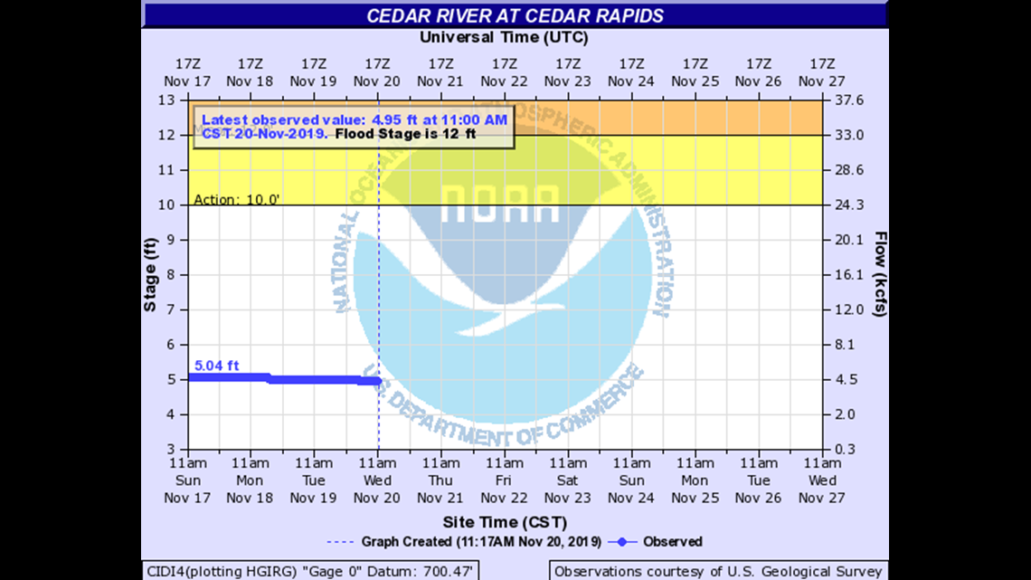
Because many of our waterways will reach or exceed major flood stage, we want to make sure you find all of the river forecast information you’re looking f...
cedarriver
Because many of our waterways will reach or exceed major flood stage, we want to make sure you find all of the river forecast information you’re looking for. Below, the forecast crest graphs from the National Weather Service and the impact that level of flooding will have on surrounding areas.
Everything you need to know about Cedar River levels
26
Sandbagging is necessary at Fairview Cemetery.
25
The 18th Street bridge is closed. Levee gates are also closed throughout the downtown area of Waterloo.
24
The following bridges are closed…Westfield Avenue…East 6th Street and West 6th Street railroad…11th Street as well as Park Avenue.
18
The access road to wastewater treatment plant is closed.
17
Many storm sewers are closed along the Cedar River.
16
The Riverview Recreation Area is closed.
Everything you need to know about Cedar River levels
19.5
Water is at the bottom of the Iowa Highway 150 bridge.
17.89
Water affects the lowest parts of Riverside Drive.
17.5
Flood protection measures such as road closures and sandbagging begin. Water affects East 2nd Street at 3rd Avenue and North 3rd Avenue at East 3rd Street.
15
Water affects much of 22nd Avenue Road.
13
Water affects the lowest part of 22nd Avenue.
12.5
Water affects the lowest part of 22nd Avenue Road.
Everything you need to know about Cedar River levels
24.2
Water reaches the bottom of the 1st Avenue bridge deck in downtown Cedar Rapids.
23.5
Water reaches the bottom of the County Road F28 bridge deck at Cedar Bluff.
22.5
Water reaches the top of a levee along 1st Street SW in Cedar Rapids.
22.2
Water reaches the bottom of the 2nd Avenue bridge deck in downtown Cedar Rapids.
20.2
Water reaches the bottom of the 3rd Avenue bridge deck and affects several homes along the river on 1st Street NW in Cedar Rapids.
19.5
Water reaches the bottom of the Blairs Ferry Road bridge deck.
19
Water reaches the bottom of a railroad bridge over the river near 1st Street NW and I Avenue NW in Cedar Rapids.
18.5
Water affects the lowest residences in Palo.
18.2
Water reaches the bottom of the railroad bridge along 8th Avenue in Cedar Rapids.
Everything you need to know about Cedar River levels
21
Water is at the bottom of the Iowa Highway 22 and County Road G28 bridges.
20
Water affects the lowest sections of County Road F70 near the river.
19
Water affects the lowest sections of U.S. Highway 6 near the river and is at the bottom of the County Road F70 bridge. Water also affects some residences in Port Allen.
18
Water affects several residences in the Rochester area and is at the bottom of the County Road F44 bridge. Water also affects the lowest areas of West Rochester Avenue and affects residences in Moscow.
17
Water affects permanent structures and roads in campgrounds just north of I-80 along the river. Water is also on the lowest areas of Atalissa Road.
16.5
Water affects County Road G28.
15.5
Water affects residences along County Road G28 and affects several gravel roads.
15
Water affects Saulsbury Road.
Downstream from Conesville, Iowa, the Cedar River flows into the Iowa River. Click here for that data.