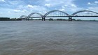
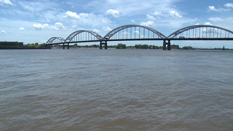
The National Weather Service has issued flood warnings for several riverfronts in the Quad Cities and surrounding areas.
The Flood Warning continues for
  The Mississippi River at Burlington.
* Until further notice.
* At  4:00 AM Thursday the stage was 17.0 feet...and steady.
* Flood stage is 15.0 feet.
* Moderate flooding is occurring and is forecast to continue.
* Forecast...Near crest now. Begin falling tonight.
* Impact...At  17.0 feet...Water affects the Port of Burlington
  parking lot.
The Flood Warning continues for
  The Mississippi River at Keithsburg.
* Until further notice.
* At  4:30 AM Thursday the stage was 15.3 feet...and steady.
* Flood stage is 14.0 feet.
* Minor flooding is occurring and is forecast to continue.
* Forecast...Near crest now. Begin falling later today.
* Impact...At  14.5 feet...Water affects low lying areas in Oquawka.
The Flood Warning continues for
  The Mississippi River at Rock Island LD15.
* Until Thursday morning.
* At  4:00 AM Wednesday the stage was 14.9 feet...and steady.
* Flood stage is 15.0 feet.
* No flooding is occurring and Minor flooding is forecast.
* Forecast...Rise to flood stage this evening.
* Impact...At  15.0 feet...Water affects several sections of South
  Concord Street south of River Drive in Davenport and is at the
  foundations of several homes on Enchanted Island. Water also
  affects industries along the river at the south end of Davenport.
The Flood Warning continues for
  The Mississippi River at New Boston LD17.
* Until further notice.
* At  4:00 AM Thursday the stage was 16.4 feet...and steady.
* Flood stage is 15.0 feet.
* Minor flooding is occurring and Moderate flooding is forecast.
* Forecast...Rise to 16.5 feet this evening...then begin falling.
The Flood Warning continues for
  The Mississippi River at Muscatine.
* Until Saturday morning.
* At  4:15 AM Thursday the stage was 16.4 feet...and steady.
* Flood stage is 16.0 feet.
* Minor flooding is occurring.
* Forecast...Near crest now. Fall below flood stage Saturday morning.
* Impact...At  16.0 feet...Water affects the lower portion of the
  Riverside Park parking lot.
The Flood Warning continues for
  The Mississippi River at Gregory Landing.
* Until further notice.
* At  4:30 AM Thursday the stage was 16.4 feet...and steady.
* Flood stage is 15.0 feet.
* Minor flooding is occurring and is forecast to continue.
* Forecast...Hover around 16.5 feet through Friday...then begin
  falling.
* Impact...At  16.0 feet...Water affects buildings in unprotected low
  areas.
The Flood Warning continues for
  The La Moine River at Colmar.
* Until this morning.
* At  3:45 AM Wednesday the stage was 20.6 feet...and falling.
* Flood stage is 20.0 feet.
* Minor flooding is occurring.
* Forecast...Fall below flood stage this morning.
The Flood Warning continues for
  The Mississippi River at Gladstone LD18.
* Until further notice.
* At  4:00 AM Thursday the stage was 12.2 feet...and steady.
* Flood stage is 10.0 feet.
* Moderate flooding is occurring and is forecast to continue.
* Forecast...Rise to 12.4 feet today...then begin falling.
The Flood Warning continues for
  The Rock River at Como.
* Until Saturday morning.
* At  4:30 AM Thursday the stage was 10.8 feet...and falling.
* Flood stage is 10.0 feet.
* Minor flooding is occurring.
* Forecast...Fall below flood stage Saturday morning.
The Flood Warning continues for
  The Rock River near Joslin.
* Until Monday morning.
* At  4:45 AM Thursday the stage was 14.2 feet...and steady.
* Flood stage is 12.0 feet.
* Moderate flooding is occurring.
* Forecast...Near crest now. Start to fall later today..falling
  below flood stage Monday morning.
* Impact...At  14.0 feet...Water affects residences in outlying areas
  immediately along the river including basements, yards, driveways,
  and access roads.
The Flood Warning continues for
  The Rock River at Moline.
* Until Sunday evening.
* At  4:30 AM Thursday the stage was 13.2 feet...and steady.
* Flood stage is 12.0 feet.
* Moderate flooding is occurring.
* Forecast...Rise to 13.3 feet this morning. Fall below flood stage
  Sunday evening.
* Impact...At  13.2 feet...Water affects 60th Street south of John
  Deere Road in Moline and 75th Ave from Green Valley Park 48th St.
  Water is on Canal Road in Big Island. Smith`s Island is affected
  by flood waters.