
An updated flood risk report said that the Mississippi River is above normal for the Quad City area.
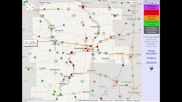
On Thursday, March 6, 2014 a Long-Range Flood Risk map became available on the National Weather Service’s website. It showed that the majority of the Quad City area has a risk of 50 percent or higher for moderate flooding.
A report released on February 20 said there was an elevated risk for flooding on the Rock River, but that the Mississippi River’s flood risk was near normal.
Now, hydrologists are saying, as of March 6, that the flood risk along the Mississippi River is above normal. This area spans from Dubuque downstream to Burlington.
The NWS map shows a moderate flood risk of 50 percent or greater that includes the Mississippi River at Rock Island and LeClaire. The Rock River is also at a 50 percent or greater risk for moderate flooding at Moline.
Further east, there is a moderate flood risk of 50 percent or greater for the Rock River near Joslin. The Green River near Geneseo has a 50 percent chance or less of flooding.
North of the Q.C., residents near Camanche and Fulton have a 50 percent chance or lower of experiencing some minor flooding from the Mississippi River.
Over in Muscatine and Illinois City, the Mississippi River has a 50 percent chance or higher for some moderate flooding.
Keep track of watches and alerts in your area – click here.
Download the free News 8 App – for iOS, click here and for Android, click here