
We may be months away but most are already curious when that first inch of snow will arrive. If so, it will likely take a track that is common in producing accumulating snow. There are four storm tracks that we monitor during a given winter season. They are the Alberta Clipper, the Colorado Low, the Panhandle Hook, and the Nor’easter. Depending on its track would determine if we get a little snow or a whole lot. Lets breakdown each of these:

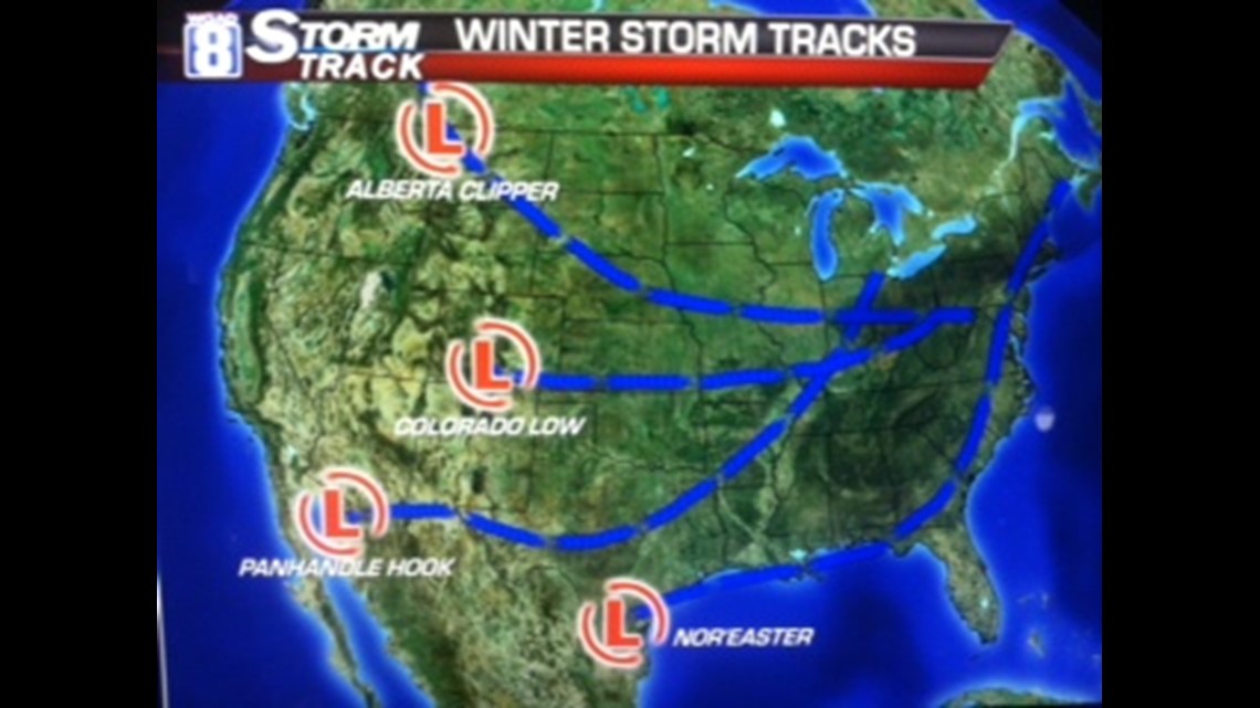
THE ALBERTA CLIPPER
This develops around the far western Canadian province of Alberta. This is a snow-starved system that races across the Northern Plains and then east across the Midwest. These clippers can carry around a good inch to as high as 4 inches of snow with blustery winds and biting cold air in its wake.
THE COLORADO LOW
This system commonly gets its name because of where it originates. This low can create decent snowfall of over 4 inches from the Plains through the Midwest to as far east as the Ohio Valley. Its not as fast compared to its cousin to the north but it can grab a decent amount of moisture from the south and thus some good shoveling conditions.
THE PANHANDLE HOOK
If you’re a snow lover than this is definitely your track. This is the big kahuna of snowstorms. The reason why it gets its name is becuase the track begins to hook over the Texas Panhandle. This stormtrack dips well south and is able to grab a good deal of gulf moisture. As the storm deepens and heads northeast toward the Great Lakes it is able to pull down cold air behind it from the north. These are capable of producing over a foot of snow with blizzard-like conditions. Remember the blizzard of 2011 which took place between January 31st to February 2nd? Wow!! Now that was some snowstorm!

Widespread 1 to 2 inch per hour snowfall rates, with thundersnow increasing the rate. Three day snowfall totals ranged as highs as 19 to 20 inches in parts of western Illinois and northeast Missouri, with wind gusts as high as 55 to 65 mph. 16.7 inches of snow fell at the QC airport on the evening of February 1st to the morning of February 2nd, setting a new 24 hour snowfall record. The Moline three day total ended with 18.4 inches!
THE NOR’EASTER
Could possibly even more intense the Panhandle Hook. These storms are noted for its movement toward the Northeast once it develops along the Gulf coast states. These winter weather events can produce heavy snow, rain, and oversized waves that crash onto Atlantic beaches, causing beach erosion and structural damage. Wind gusts associated with these storms can exceed hurricane force. As you can see by its track, its chance of producing any local snowfall is light at best.
So, there you have it. What will be the more common track this coming season? As you guessed, its way too early to call. If you want more cold than snow, then hope for more Alberta Clippers. If you think we didn’t receive enough snow last year, then start rooting for more Colorado Lows and Panhandle Hooks!! I know I am. 🙂