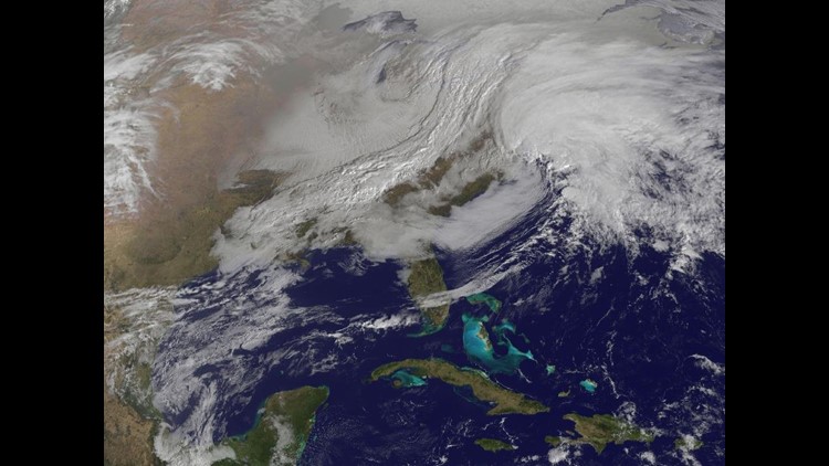

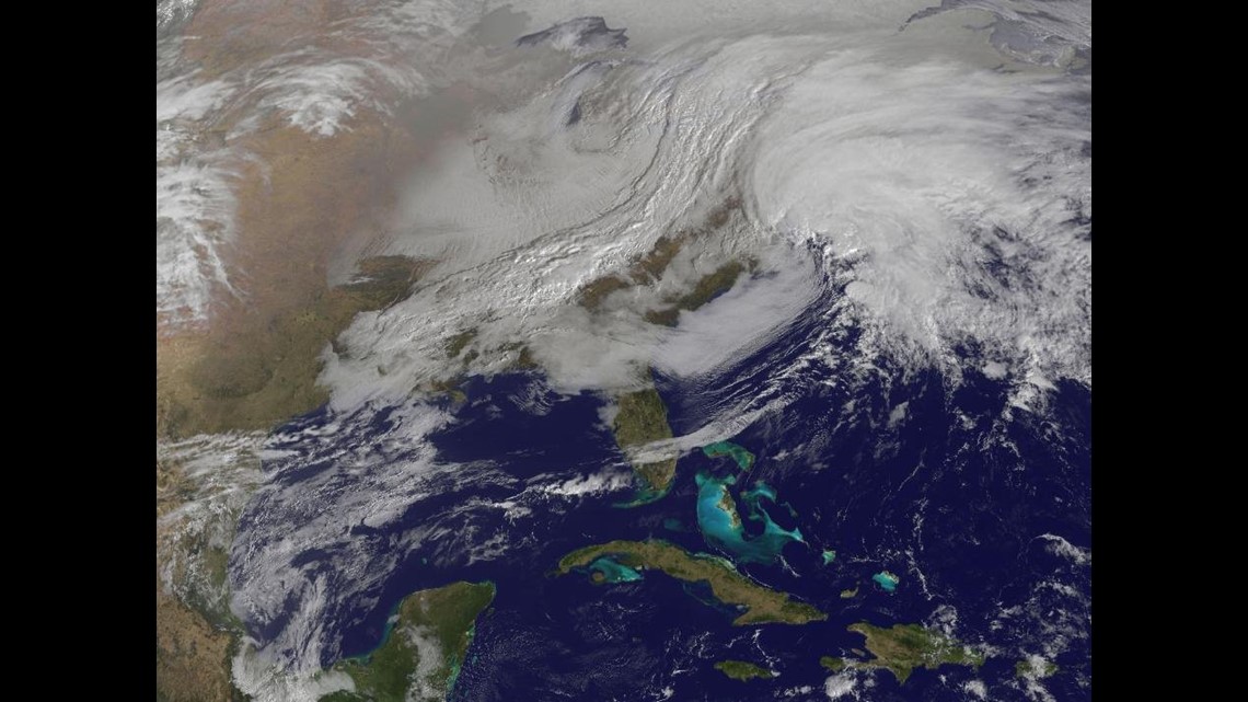
NASA’s image of the day for Friday, February 8, 2013 is a shot of the massive winter storm taking aim at the northeastern U.S.
The satellite image taken at 9:01 a.m. Eastern Standard Time shows the cold front as it stretches from Canada to the Gulf of Mexico and merges with a low-pressure system over the Atlantic coast.
NEW YORK (CNN) — As a pair of powerful storm systems converge across the Northeast, a veteran snowplow driver from outside Boston is one of thousands of workers trying to keep ahead of the weather.
“It just started to get worse,” said Chris Moran while plowing the streets of downtown Boston. “The road conditions are deteriorating fast. And the wind has picked up substantially.”
For the last three decades, Moran has bundled up and braved the biting cold to fight off the snow as a commerical driver throughout eastern Massachusetts.
From the “Great Blizzard of ’78” to the “Presidents Day Storm of 2003,” Moran has been there, scraping flurries off the streets.
Since Thursday, the 42-year-old Framingham resident has been salting city roadways, parking lots and sidewalks along with an army of municipal workers and private contractors as blizzard conditions rolled in.
“Once it starts snowing hard, we’ll be plowing and trying to keep up,” he said.
Beantown is expected to get the worst of it, with the heaviest weather starting Friday at around 5 p.m. until Saturday morning, with up to two feet in snow. The size and scope of this storm, forecasters say, could be of historic proportions.
“I want to be clear — 2 or 3 feet of snow in this period of time is a profoundly different type storm than we’ve had to deal with,” said Massachusetts Gov. Deval Patrick.
Snowfall could descend anywhere between 2 and 3 inches per hour at the height of the blizzard — leaving workers like Moran struggling to keep up.
“If it gets really bad, we’re just going to have to wait, dig out and then catch up,” he said. “Either way, I’ll be up all night.”
Governors across New England have declared states of emergency, and all cars and trucks — except emergency vehicles — must now be off Massachusetts and Connecticut roadways. A similar ban in Rhode Island took effect at 5 p.m.
Violating that ban could incur a penalty of up to a year in jail and a $500 fine.
“We are hardy New Englanders,” said Boston Mayor Thomas Menino, who urged residents to use caution, stay indoors and wait out the storm.
Accumulations are expected to continue through Saturday and spawn potentially deadly weather. Tens of millions of people are in the blizzard’s path and a trail of thousands of canceled flights has already frustrated travel plans in some 60 airports across the nation.
Amtrak has also canceled many trips in the Northeast corridor. And some 6,000 Massachusetts National Guardsmen were put on storm duty as residents across the region stocked up on essential supplies.
“People seemed like they wanted to be prepared, but not necessarily scared,” said Ocheme Saleh, a 20-year-old Boston resident and university student.
Lines of customers snaked around storefronts as many braced for the incoming wintry weather.
When Reading, Massachusetts, resident Elizabeth Frazier arrived at a grocery store late Thursday night, shoppers were already buying up the store.
“It’s a zoo in there,” she said. “There’s nothing left on the shelves,” she told CNN affiliate WHDH.
Blizzard warnings are in effect across Connecticut, Massachusetts, Maine and Rhode Island. And winter storm watches remained in Vermont, New Hampshire, New York and New Jersey.
Wind gusts in Maine could reach 50 mph and are expected to usher in heavy snow fall later Friday evening as authorities there also urged caution. A 19-car pileup near Portland temporarily closed roadways, though all injuries were considered minor.
High winds could also stir up trouble at sea and push flood waters up and over Northeastern coastlines, adding to the misery to those who lost their homes just months ago in Superstorm Sandy.
“We don’t have anything else to lose at this point,” said Steve Chati, who lives in Staten Island, New York. “We’re just trying to stay strong.”
New York’s heaviest snowfall is expected to start falling at 7 p.m. Friday, with accumulations of up to about a foot.
“It’s going to be one of the strongest winter storms we’ve seen in a very long time,” said CNN meteorologist Pedram Javaheri.
By Friday afternoon, a fleet of 1,700 snow plows had geared up across New York City. Motorists also queued up to fill their tanks as salt spreaders fanned out in an effort to head off the weather.
“If it’s going to happen, having it happen Friday overnight into Saturday is probably as good timing as we could have,” said Mayor Michael Bloomberg. “The sanitation department then has the advantage of being able to clean the streets when there’s normally less traffic.”
Utility companies said they were shoring up resources in expectations of power outages and downed power lines as high winds picked up throughout the region.
Consolidated Edison, one of the region’s main providers, said more than 800 customers have since lost power as forecasters predict snowfalls could last as long as 36 hours in some areas, breaking local accumulation records.